| Susquehanna River | |
| River | |
 Susquehanna River near Chesapeake Bay
| |
| Country | USA |
|---|---|
| States | Maryland, Pennsylvania, New York |
| Tributaries | |
| - right | West Branch, Juniata River |
| Cities | Harrisburg, PA, Wilkes-Barre, PA, Binghamton, NY |
| Source | Otsego Lake |
| - elevation | 1,180 ft (360 m) |
| - coordinates | Template:CountryAbbr/debug 42°42′02″N 74°55′10″W / 42.70056°N 74.91944°W |
| Secondary source | West Branch Susquehanna River |
| - elevation | 1,980 ft (604 m) |
| - coordinates | Template:CountryAbbr/debug 40°35′55″N 78°42′56″W / 40.59861°N 78.71556°W |
| Mouth | Chesapeake Bay |
| - elevation | 0 ft (0 m) |
| - coordinates | Template:CountryAbbr/debug 39°32′35″N 76°04′32″W / 39.54306°N 76.07556°W |
| Length | 444 mi (715 km) |
| Basin | 27,500 sq mi (71,225 km2) |
| Discharge | for Conowingo Dam, MD |
| - average | Template:Unit discharge |
| - max | Template:Unit discharge |
| - min | Template:Unit discharge |
| Discharge elsewhere (average) | |
| - Danville, PA | Template:Unit discharge |
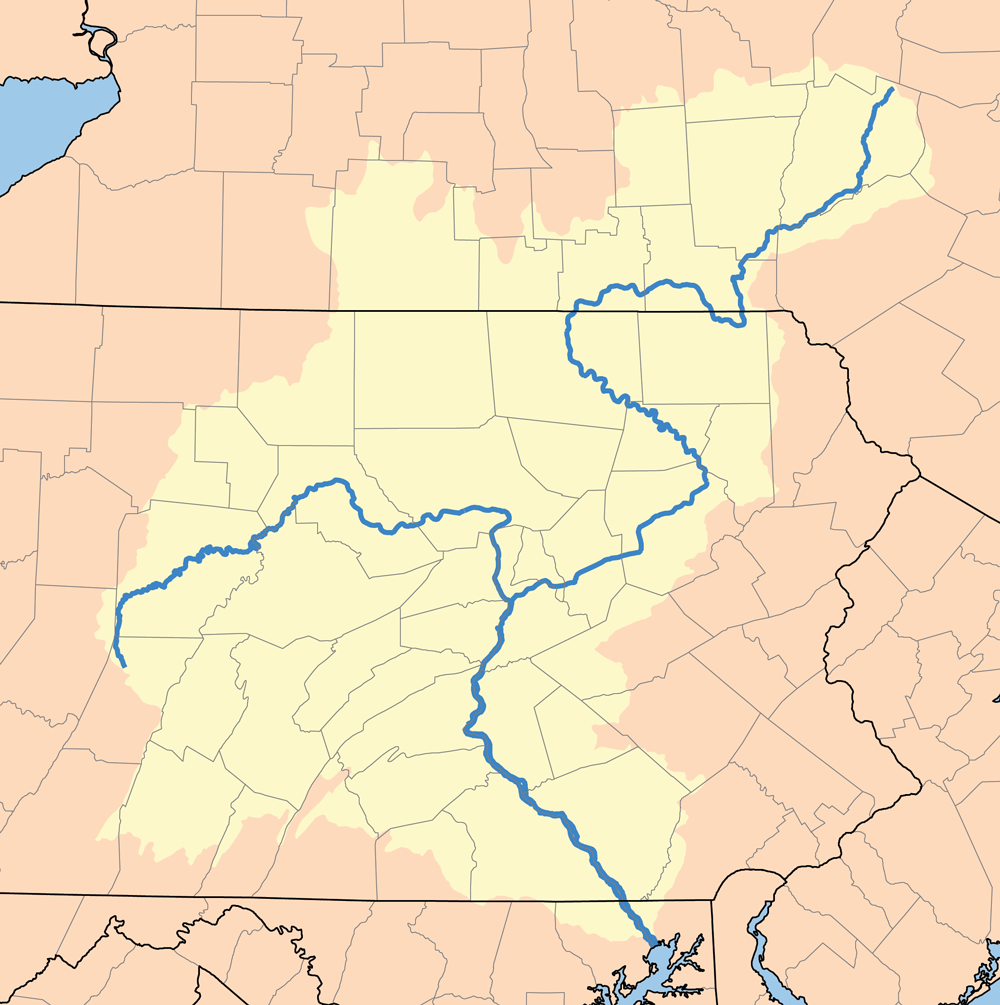 The Susquehanna watershed
| |
The Susquehanna River (originally "Sasquesahanough" according to the 1612 John Smith map) is a river located in the northeastern United States. At approximately 444 mi (715 km) long, it is the longest river on the American east coast, the 16th longest in the United States, and the longest river in the continental United States without commercial boat traffic. The Susquehanna forms from two main branches, with the North Branch, which rises in upstate New York often regarded as an extension of the main branch. The shorter West Branch, which rises in western Pennsylvania, is sometimes regarded as the principal tributary, joining the North Branch near Northumberland in central Pennsylvania. The river drains 27,500 square miles (71,225 km²), covering nearly half of the land area of Pennsylvania and portions of New York and Maryland. The drainage basin (watershed) includes portions of the Allegheny Plateau region of the Appalachian Mountains, cutting through water gaps in the lateral mountain ridges in a broad zigzag course to flow across the rural heartland of southeastern Pennsylvania and northeastern Maryland. The river empties into the northern end of the Chesapeake Bay, the ria of the Susquehanna, providing half of the freshwater inflow for the entire Chesapeake Bay.
Course[]
Rising as the outlet of Otsego Lake in Cooperstown, New York, the north branch of the river runs west-southwest through dairy country, receiving the Unadilla River at Sidney and the Chenango in downtown Binghamton. At Athens Township (just south of Waverly, NY) in northern Pennsylvania, just across the New York state line, it receives the Chemung from the northwest and makes a right angle curve between Sayre and Towanda to cut through the Endless Mountains in the Allegheny Plateau. It receives the Lackawanna River southwest of Scranton and turns sharply to the southwest, flowing through the former anthracite industrial heartland in the mountain ridges of northeastern Pennsylvania, past Wilkes-Barre, Nanticoke, Berwick, Bloomsburg, and Danville. It receives the smaller West Branch from the northwest at Northumberland, just above Sunbury.

Harrisburg, with the state capitol dome, from across the Susquehanna River
Downstream from the confluence of its branches it flows south past Selinsgrove, where it is joined by its Penns Creek tributary, and cuts through a water gap at the western end of Mahantongo Mountain. It receives the Juniata River from the northwest at Duncannon, then passes through its last water gap, through Blue Mountain, just northwest of Harrisburg. It passes downtown Harrisburg (where it is nearly a mile wide), the largest city on the lower river, and flows southeast across South Central Pennsylvania, forming the border between York and Lancaster counties, as well as receiving Swatara Creek from the northeast. It crosses into northern Maryland approximately 30 miles (50 km) northeast of Baltimore, where it is joined by Octoraro Creek. Finally the river enters the northern end of the Chesapeake Bay at Havre de Grace, where Concord Point Light was built in 1827 to accommodate the increasing navigational traffic.[1]
Geology[]
Geologically, the river is extremely ancient, often regarded as the oldest or second oldest major system in the world. It is far older than the mountain ridges through which it turns, most of which were formed in uplift events of the early Cenozoic era. Like the Hudson, Delaware and Potomac rivers, the basin was well-established in the flat plains that existed during the Mesozoic era.[2] There is evidence that the flow of the ancient Susquehanna was established early enough that it predated the Appalachian orogeny over 300 million years ago, meaning that the river was in existence well before Pangea broke up and formed the Atlantic Ocean.
Before the end of the last ice age, the Susquehanna was a much longer river. The Chesapeake Bay constituted its lower valley before it was flooded by rising waters at the conclusion of the Pleistocene, a formation known as a ria.
Pollution[]


Satellite photo of the Susquehanna (upper left) where it empties into Chesapeake Bay (center)
The environmental group American Rivers named the Susquehanna "America's Most Endangered River for 2005" due to the excessive pollution it receives. Most of the pollution in the river is due to excess animal manure from farming, agricultural runoff, urban and suburban stormwater runoff, and raw or inadequately treated sewage. In 2003 the river alone contributed 44% of the nitrogen, 21% of the phosphorus, and 21% of the sediment flowing into the Chesapeake Bay. Pennsylvania may be subject to EPA sanctions if it does not reduce its pollution in the watershed by 2010.[3] It was designated as one of the American Heritage Rivers in 1997.[4] The designation provides for technical assistance from federal agencies to state and local governments working in the Susquehanna watershed.
Historic importance[]
The river has played an important role throughout the history of the United States. Before European conquest, the Susquehannock, an Iroquoian tribe lived along the river and gave the Susquehanna its name. In the 17th century, it was inhabited largely by the Lenape, forming roughly the western boundary of their inhabited territory, known as Lenapehoking. In the 18th century, William Penn, the founder of the Pennsylvania Colony, negotiated with the Lenape to allow white settlement in the colony between the Delaware River and the Susquehanna. Local legend claims that the name of the river comes from an Indian phrase meaning "mile wide, foot deep," referring to the Susquehanna's unusual dimensions, but while the word is Algonquian, it simply means "muddy current."[5][6] or "winding current"[7][8]
In the late colonial times, the river became an increasingly important transportation corridor with the discovery of anthracite coal by Necho Allen in its upper reaches in the mountains. In 1790, Colonel Timothy Matlack, Samuel Maclay and John Adlum were commissioned by the Supreme Executive Council of the Commonwealth of Pennsylvania to survey the headwaters of the river and explore a route for a passageway to connect the West Branch with the waters of the Allegheny River.[9] In 1792, the Union Canal was proposed linking the Susquehanna and the Delaware along Swatara Creek and Tulpehocken Creek. In the 19th century, the river became the scene of the growth of industrial centers.
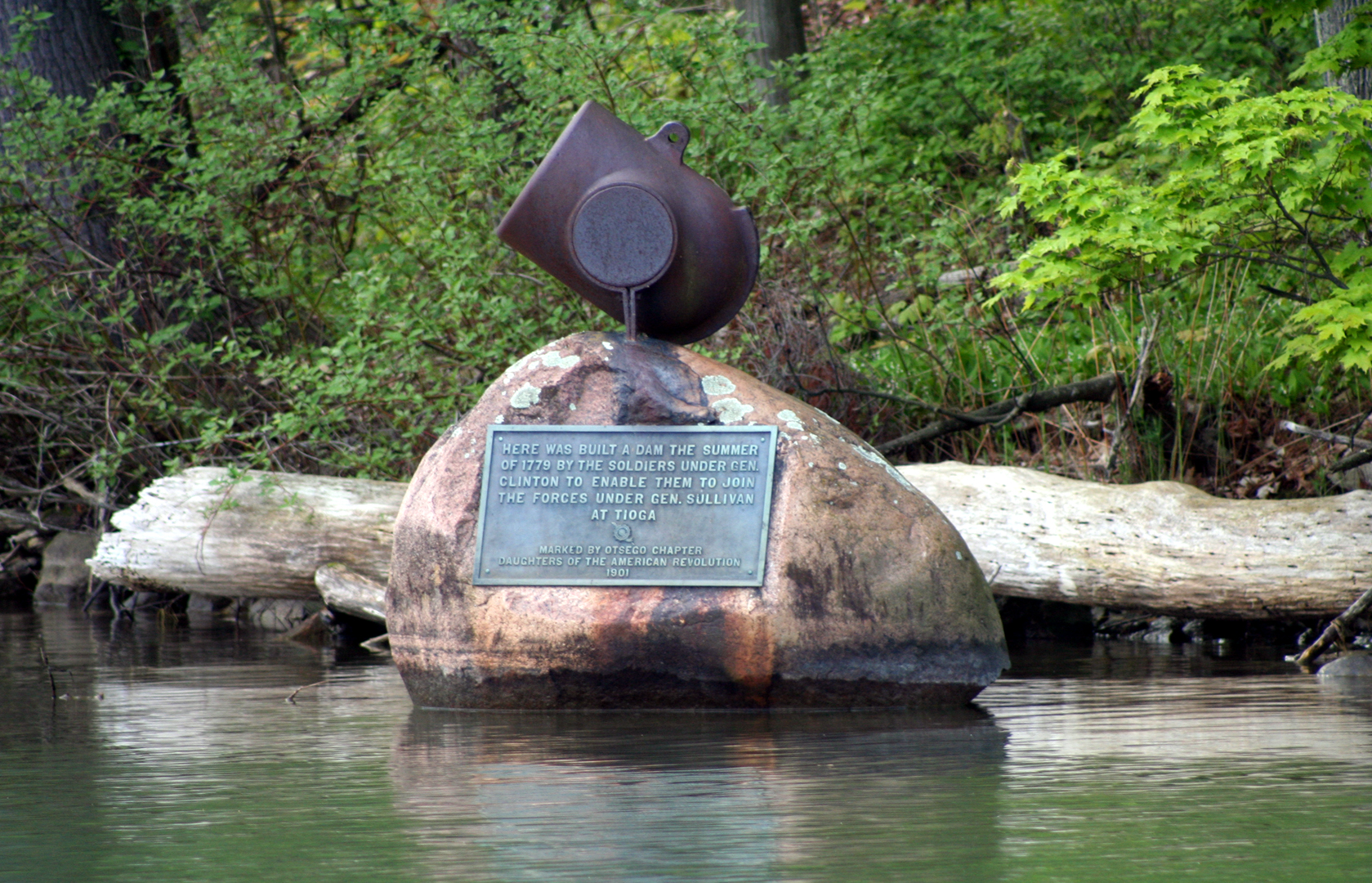

Monument at the site of Gen. Clinton's dam at the source of the Susquehanna River on Otsego Lake in Cooperstown, New York
In 1779 General James Clinton led an expedition down the Susquehanna after making the upper portion navigable by damming up the river's source at Otsego Lake, allowing the lake's level to rise, and then destroying the dam and flooding the river for miles downstream. This event is described by James Fenimore Cooper in the introduction to his popular novel The Pioneers. At Athens, Pennsylvania, then known as Tioga or "Tioga Point", Clinton met up with General John Sullivan's forces, who had marched from Easton, Pennsylvania. Together on August 29, they defeated the Tories and Indians at the Battle of Newtown (near today's city of Elmira, New York). This became known as the "Sullivan-Clinton Campaign" or the "Sullivan Expedition."
Conflicting land claims by Pennsylvania and Connecticut to the Wyoming Valley along the Susquehanna led to the founding of Westmoreland County, Connecticut, and the Pennamite Wars, which eventually led to the territory being ceded to Pennsylvania.
The Susquehanna River holds importance for members of The Church of Jesus Christ of Latter-day Saints as the location where Joseph Smith, Jr. and Oliver Cowdery received the priesthood from heavenly beings. On 15 May 1829, according to section 13 of the Doctrine and Covenants, they were visited by the resurrected John the Baptist. Following his visit, Joseph and Oliver baptized each other in the river. Later that year, they were also visited near the river by the apostles Peter, James and John, as alluded to in sections 27 and 128 of the Doctrine and Covenants. Both events took place in unspecified locations near the river's shore in either Susquehanna County, or Broome County.
During the American Civil War's 1863 Gettysburg Campaign, the commander of the Department of the Susquehanna, Union Major General Darius N. Couch resolved that Robert E. Lee's Confederate Army of Northern Virginia would not cross the Susquehanna. He positioned militia units under Maj. Granville Haller to protect key bridges in Harrisburg and Wrightsville, as well as nearby fords. Confederate forces approached the river at several locations in Cumberland and York counties, but were recalled on June 29 when Lee chose to concentrate his army to the west.
In 1972, the remnants of Hurricane Agnes stalled over the New York-Pennsylvania border, dropping as much as 20 inches (50.8 cm) of rain on the hilly lands. Much of that precipitation was received into the Susquehanna from its western tributaries, and the valley suffered disastrous flooding. Wilkes-Barre, Pennsylvania, was among the hardest hit communities. The Chesapeake Bay received so much fresh water that it killed much of the marine life.
In 1979, the river was the scene of the most serious nuclear power accident in U.S. history at Three Mile Island southeast of Harrisburg.
In June 2006, significant portions of the river system were affected by the Mid-Atlantic Flood of June 2006, a flood caused by a stalled jet stream-driven storm system. The most significantly affected area in the Susquehanna river basin was in and around the Binghamton, NY region, where flooding exceeded historical records and forced the evacuation of thousands of residents and the destruction of significant amounts of property and infrastructure.
Boating[]
The Susquehanna is a favorite place to use powered and unpowered boats in Pennsylvania. For kayakers there are some excellent rapids. Dauphin Narrows just above Harrisburg is an excellent place for a beginner white water kayaker. Below the Holtwood Dam at high water there is some world class white water for the very experienced boater. There is a nice surfing wave at Brainbridge above York called "the Wave," it is a challenge for intermediate kayakers!
Rowing[]
Rowing on the Susquehanna River has a long history. Starting in 1874, rowers from Shamokin Dam raced men from Sunbury. The General Clinton Canoe Regatta is the world's longest flatwater race and takes place each year in Bainbridge New York on Memorial Day Weekend.
Bridges, ferries, canals and dams[]
|
|
This section requires expansion. |
The Susquehanna River has always loomed large in the transportation history of the United States. Prior to the 1818 opening of the Port Deposit Bridge, the river formed a barrier between the northern and southern states, crossable only by ferry. The earliest dams were constructed to support ferry operations in low water. The presence of many rapids in the river meant that while commercial traffic could navigate down the river in the spring thaws, nothing could move up. This led to the construction of two different canal systems on the lower Susquehanna; the first was the Susquehanna Canal, also called the Conowingo Canal or the Port Deposit Canal, completed in 1802 by a Maryland company known as the Proprietors of the Susquehanna Canal; the second was the much longer and more successful Susquehanna and Tidewater Canal. The canals required additional dams to provide canal water and navigation pools. As the industrial age progressed, bridges replaced ferries, and railroads replaced canals, often built right on top of the canal right of way along the river. Many canal remnants can be seen in Havre de Grace, Maryland, along US Route 15 in Pennsylvania, and in upstate New York at various locations. These latter remnants are parts of the upstream divisions of the Pennsylvania Canal, of privately funded canals, and of canals in the New York system.
Today, there are over two hundred bridges crossing the Susquehanna. The sole remaining ferry, at Millersburg, Pennsylvania, is a seasonal tourist attraction. The canals are gone or are part of historical parks, and dams are related to power generation or recreation. Perhaps the most famous of the bridges, the Rockville Bridge, crosses the river from Harrisburg, Pennsylvania, to Marysville, Pennsylvania. The Rockville Bridge, when constructed, was the longest stone masonry arch bridge in the world. It was built by the Pennsylvania Railroad in the early 1900s, replacing an earlier iron bridge.
See also[]
- List of Maryland rivers
- List of New York rivers
- List of Pennsylvania rivers
- Spades Wharf Island
- McCormick Island
- City Island (Pennsylvania)
- Geography of Pennsylvania
Notes[]
- ↑ Simms, William Q.. "Two Lights on the Hill". Lighthouse Digest, Inc.. http://www.lhdigest.com/Digest/StoryPage.cfm?StoryKey=1004. Retrieved 2006-12-28.
- ↑ "Description of the Geology of York County Peninsula". Penn State University Libraries. http://www.libraries.psu.edu/emsl/guides/X/york.htm. Retrieved 2007-10-26.
- ↑ Chesapeake Bay Foundation. Annapolis, MD. "Susquehanna River Named America's Most Endangered River for 2005." April 13, 2005.
- ↑ U.S. Environmental Protection Agency (EPA). Washington, D.C. "American Heritage Rivers: Upper Susquehanna and Lackawanna Rivers." October 19, 2006.
- ↑ Kelton, Dwight H. Indian Names of Places Near the Great Lakes. (Detroit, MI: Detroit Free Press Printing Company, 1888).
- ↑ c.f. Anishinaabe language azhashkijiwan "be a muddy current"
- ↑ Halsey, Francis Whiting (1901). The Old New York Frontier. (New York: Charles Scribner's Sons.)
- ↑ c.f. Anishinaabe language zazagijiwan "be a winding current"
- ↑ Storey, Henry Wilson. "History of Cambria County, Pennsylvania." New York: The Lewis Publishing Company, 1907.
External links[]
- U.S. Geological Survey: PA stream gaging stations
- Susquehanna River Basin Commission
- American Rivers article: Susquehanna River "Most Endangered"
- History of the Susquehanna River Ark
Template:Geolinks-US-river
Template:Susquehanna River System Template:Maryland waters
| |||||||||||||||||||||||||||||||||||
Template:AHR
cs:Susquehanna pdc:Susquehanna Rewwer sw:Mto Susquehanna lt:Saskuehana hu:Susquehanna no:Susquehanna (elv) pt:Rio Susquehanna ru:Саскуэханна sl:Susquehanna (reka) sv:Susquehanna zh:薩斯奎哈納河