| City of Liberty, Missouri | |
|---|---|
| — City — | |
 |
|
| Coordinates: 39°14′27″N 94°25′35″W / 39.24083°N 94.42639°W | |
| Country | United States |
| State | Missouri |
| County | Clay |
| Government | |
| - Type | Mayor-Council-Administrator |
| - Mayor | Greg Canuteson |
| Area | |
| - Total | 28.9 sq mi (74.8 km2) |
| - Land | 28.8 sq mi (74.6 km2) |
| - Water | 0.1 sq mi (0.2 km2) |
| Elevation | 886 ft (270 m) |
| Population (2007) | |
| - Total | 29,993 |
| - Density | 1,056.6/sq mi (407.5/km2) |
| Time zone | CST (UTC-6) |
| - Summer (DST) | CDT (UTC-5) |
| ZIP codes | 64068, 64069 |
| Area code(s) | 816 |
| FIPS code | 29-42032[1] |
| GNIS feature ID | 0730132[2] |
| Website | http://www.ci.liberty.mo.us |
Liberty is a city in Clay County, Missouri and is a suburb of Kansas City, Missouri. At the 2007 population estimate, the city population was 29,993.[3] It is the county seat of Clay County[4]. Liberty is also home to William Jewell College.
History[]
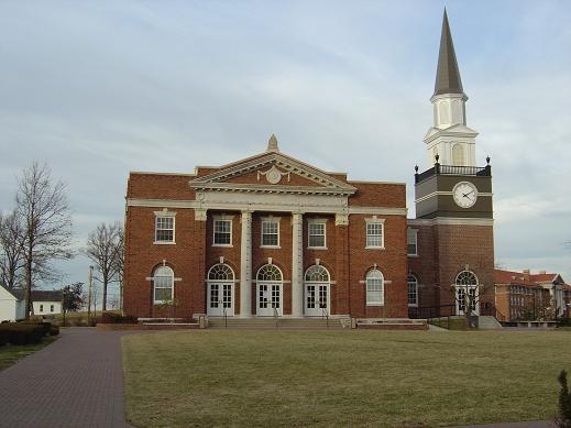
Gano Chapel from the Quad in 2004 after the clock tower had been repaired following the 2003 tornado.
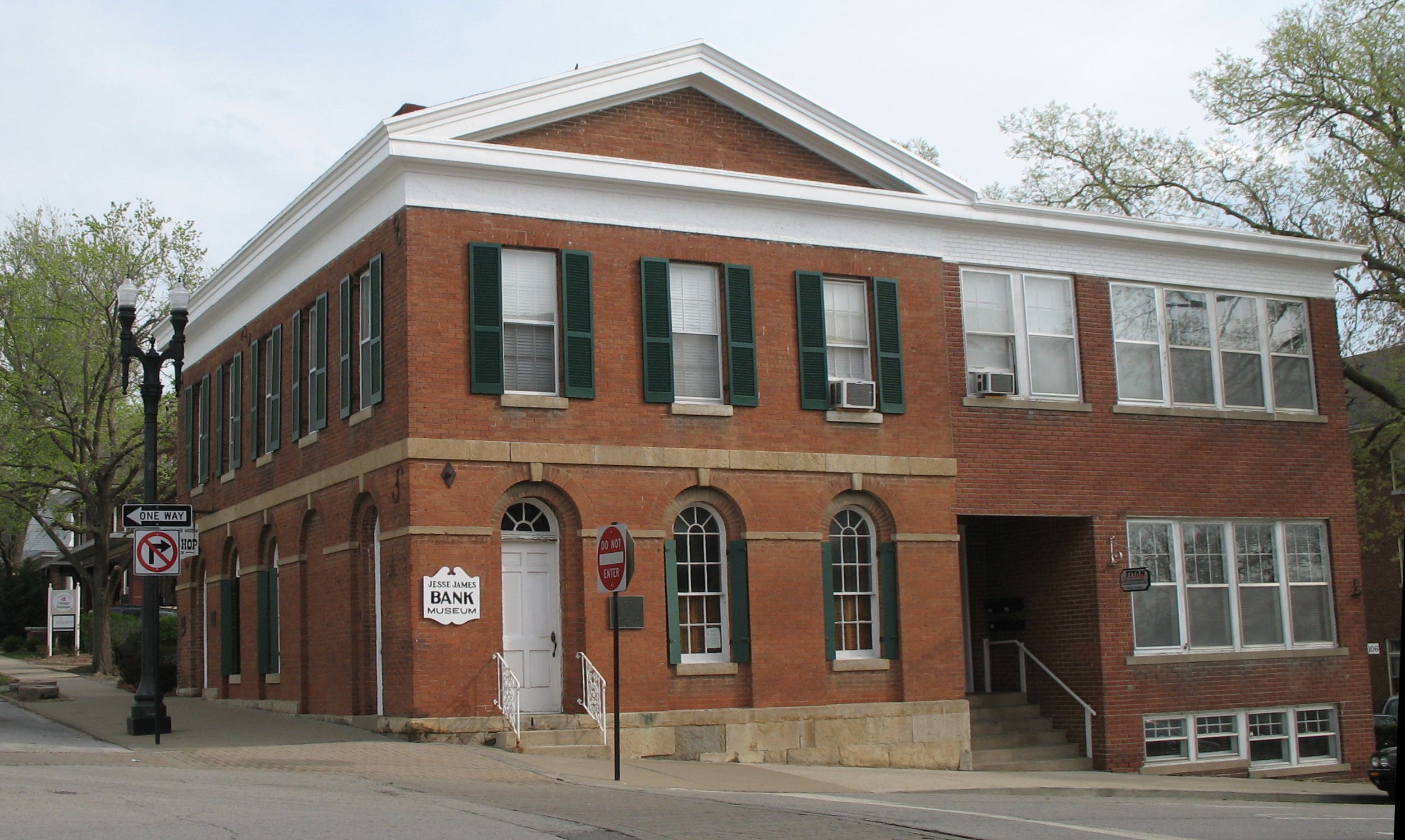
Clay County Savings Association building

Historic Liberty Jail museum
Liberty was settled in 1822, and shortly later became the county seat of Clay County.
In 1830, David Rice Atchison established a law office in Liberty. He was joined three years later by colleague Alexander William Doniphan. The two argued cases defending the rights of Mormon settlers in Jackson County, served Northwest Missouri in Missouri's General Assembly, and labored for the addition of the Platte Purchase to Missouri's boundaries.[5] In October 1838, the two were ordered by Governor Lilburn Boggs to arrest Mormon prophet Joseph Smith Jr. at the Far West settlement in Caldwell County.[5] Immediately after the conclusion of the Mormon War, Smith and other Mormon leaders were incarcerated at the Liberty Jail for the winter as Doniphan labored for a quicker trial date. Although Doniphan led a force of Missouri volunteers ordered to capture the leaders, he defended Joseph Smith in trial and won him a change in venue. While en route to their new venue, Smith and his followers escaped and left Missouri for the new Mormon settlement in Nauvoo, Illinois.[5]
Atchison relocated to Plattsburg in Clinton County, as Doniphan continued to make his name in Liberty. Doniphan would join a company of Clay County men and command the 1st Missouri Mounted Volunteers Regiment during the Mexican-American War. The wartime fervor was covered by the Liberty Tribune, founded in April 1846.
In 1849, Liberty became the home of William Jewell College.
During the Civil War, sympathies for the Confederacy were prevalent in Liberty. In the 1860 Presidential Election, no votes in Clay County went to Abraham Lincoln.
A few days after the firing on Fort Sumter a Confederate mob seized the Liberty Arsenal disrupting Missouri's plans to remain with the Union but neutral. The seizure, which was the first skirmish in the state during the war, eventually led to the eviction of Missouri's elected governor and has sometimes been called "Missouri's Fort Sumter"
In September 1861, in the Battle of Liberty Union troops unsuccessfully attempted to stop Confederate sympathizers led by Atchison from crossing the Missouri River to reinforce Confederate position in the Battle of Lexington I. There were 126 casualties. The Union army used William Jewell College as a hospital and buried their dead on campus.
Liberty was to also see action in the August 1862 siege of Independence.
Southern sentiment remained in the city long after the Civil War—city hall reportedly refused to fly the United States Flag until the start of World War I.
Liberty was the site of the first daytime bank robbery in the United States during peacetime, on February 13, 1866 at the Clay County Savings Association. The gang led by Jesse James was purportedly responsible for the robbery and death of one William Jewell student.
Education opportunities blossomed in the latter half of the 19th century. Liberty High School was chartered in 1890, the county's oldest four-year institution. Liberty Ladies College opened on a hill due west of Jewell that same year. The school burned down in 1913, resulting in its merger with Jewell. Liberty also housed many privately owned boarding schools. At one operated by Professor Love, a complacent student named Carrie Nation was driven to tears when she was unable to formulate an argument for a class debate concerning animal sentience.
Also in 1913, Liberty was connected to Kansas City by way of the Interurban rail system. Transportation links between the growing metropolis and Liberty increased with the addition of State Route 10 in 1922 and its conversion to U.S. Route 69 in 1926. The electric railway ceased operations in 1933. The addition of Interstate 35 in the 1960s along portions of US 69 brought new expansion to Liberty, creating car-filled suburban neighborhoods oriented toward Kansas City.
William Jewell was the NFL Training Camp for the Kansas City Chiefs until 1991.
On May 4, 2003, a "high end" F2 tornado that was part of the May 2003 tornado outbreak sequence struck the downtown and William Jewell campus heavily damaging numerous buildings. Although damage is estimated at between $15 and $20 million, nobody at the school was killed or injured. Classes resumed in the fall.
Today[]


South side of the Clay County Courthouse (designed by Wight and Wight), which anchors the Liberty Square.
Liberty is among the largest suburbs of Kansas City. The city limits of Kansas City touch the western and southern borders of Liberty. Some businesses formerly in Liberty moved across I-35 to Kansas City, lured by tax abatements and room for expansion. Liberty is redeveloping the Liberty Triangle, an 88-acre (360,000 m²) parcel bound by I-35 and Routes 152 and 291. Liberty proposed annexing three unincorporated areas in 2005/2006. The first two went to a vote in 2006 and one was approved. A third area is expected to be put on the ballot in the near future and would more than double the city in size. All three areas would increase out the city boundaries to the school district boundaries.
Major employers in Liberty include the Hallmark distribution warehouse. Liberty is also home to the operations headquarters for Ferrellgas, the largest retail provider of propane in the United States.
The Liberty Public School District serves Liberty, Glenaire, along with portions of Kansas City and unincorporated Clay County. Its schools (9 elementary, 2 middle, 2 junior high, 1 senior high (with an additional senior high, junior high, and middle school planned)) have ranked among the best in Missouri in recent years, with achievement of multiple athletic and academic state titles and championships in recent years as well as high-performance district honors from the Missouri Department of Elementary and Secondary Education.
Geography[]
Liberty is located at 39°14′27″N 94°25′35″W / 39.24083°N 94.42639°W (39.240852, -94.426502)[6]. According to the United States Census Bureau, the city has a total area of 28.9 square miles (74.8 km²).74.6 km² (28.8²) of it is land and 0.1 square miles (0.2 km²) of it (0.22%) is water.
Demographics[]
As of the census[1] of 2000, there were 26,232 people, 9,511 households, and 6,943 families residing in the city. The population density was 973.3 people per square mile (375.8/km²). There were 9,973 housing units at an average density of 370.0/sq mi (142.9/km²). The racial makeup of the city was 93.75% White, 2.59% African American, 0.40% Native American, 0.61% Asian, 0.06% Pacific Islander, 0.99% from other races, and 1.59% from two or more races. Hispanic or Latino of any race were 2.68% of the population.
There were 9,511 households out of which 38.9% had children under the age of 18 living with them, 59.2% were married couples living together, 10.9% had a female householder with no husband present, and 27.0% were non-families. 22.4% of all households were made up of individuals and 7.9% had someone living alone who was 65 years of age or older. The average household size was 2.62 and the average family size was 3.08.
In the city the population was spread out with 27.6% under the age of 18, 10.4% from 18 to 24, 30.2% from 25 to 44, 21.5% from 45 to 64, and 10.4% who were 65 years of age or older. The median age was 34 years. For every 100 females there were 91.9 males. For every 100 females age 18 and over, there were 89.6 males.
The median income for a household in the city was $52,745, and the median income for a family was $61,273. Males had a median income of $41,713 versus $28,516 for females. The per capita income for the city was $23,415. About 3.8% of families and 5.0% of the population were below the poverty line, including 5.1% of those under age 18 and 6.1% of those age 65 or over.
Twin Towns[]
 Diekirch, Luxembourg
Notable people[]
- Ken Boyer, former third baseman and coach of the St. Louis Cardinals
- James Dewees, keyboardist and back-up vocalist of The Get Up Kids, and started Reggie and the Full Effect.
- Hubert Eaton, visionary and developer of the world-famous Forest Lawn cemeteries in California
- Craig Stevens, star of the 1950s television series Peter Gunn
- Matt Wertz, soft rock singer/songwriter
References[]
- ↑ 1.0 1.1 "American FactFinder". United States Census Bureau. http://factfinder.census.gov. Retrieved 2008-01-31.
- ↑ "US Board on Geographic Names". United States Geological Survey. 2007-10-25. http://geonames.usgs.gov. Retrieved 2008-01-31.
- ↑ City of Liberty offical website
- ↑ "Find a County". National Association of Counties. http://www.naco.org/Template.cfm?Section=Find_a_County&Template=/cffiles/counties/usamap.cfm. Retrieved 2008-01-31.
- ↑ 5.0 5.1 5.2 Muench, James F. (2006). Five Stars: Missouri's Most Famous Generals. Columbia, Missouri: University of Missouri Press. pp. 7-17. ISBN 9780826216564. http://books.google.com/books?id=PKvpsMbH5goC&pg=1.
- ↑ "US Gazetteer files: 2000 and 1990". United States Census Bureau. 2005-05-03. http://www.census.gov/geo/www/gazetteer/gazette.html. Retrieved 2008-01-31.
External links[]
- Liberty, Missouri is at coordinates 39°14′27″N 94°25′35″W / 39.240852°N 94.426502°WCoordinates: 39°14′27″N 94°25′35″W / 39.240852°N 94.426502°W
| ||||||||||||||||

|
| ||||||||||||||||||||

| |||||
io:Liberty, Missouri ht:Liberty, Missouri pt:Liberty (Missouri) simple:Liberty, Missouri sv:Liberty, Missouri vo:Liberty (Missouri)