Hama (ancient Hamath; Arabic: حماة Ḥamāh, "fortress") is a city on the banks of the Orontes River in central Syria north of Damascus. It is the provincial capital of the Hama Governorate. The city is the location of the historical city Hamath. The population of Hama is 410,000, and the city is the fifth-largest in Syria, after Damascus, Aleppo, Hims and Latakia.
Hama is an important agricultural and industrial center in Syria, with 3,680 square kilometres (1,420 sq mi), over a third of the governorate's area under cultivation. The governorate produces over half of the national crop of potatoes and pistachio nuts, as well as growing a variety of other vegetables. Livestock ranching is also common in the governorate.
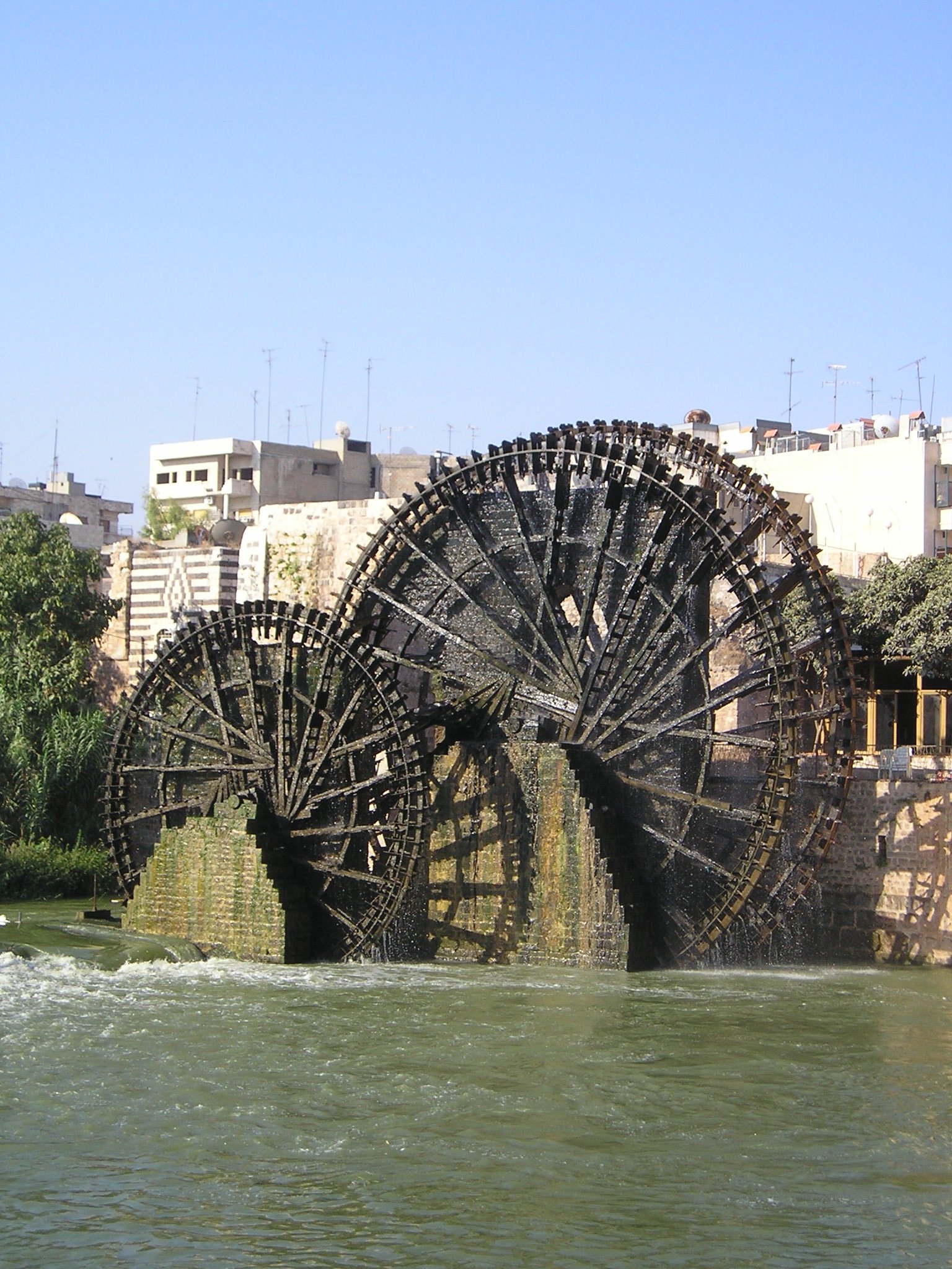
The city proper is renowned for its 17 norias used for watering the gardens, which—it is claimed—date back to 1100 BC. Though historically used for purpose of irrigation, the norias exist today as an almost entirely aesthetic traditional show.
History
Ancient era
The ancient settlement of Hamath was occupied from the early Neolithic to the Iron Age. Remains from the Chalcolithic era have been uncovered by Danish archaeologists on the mount of the mount on which the former citadel once stood.[1] The excavation took place between 1931 and 1938 under the direction of Harald Ingholt. The stratigraphy is very generalised, which makes detailed comparison to other sites difficult. Level M (6 m or 20 ft thick) contained both white ware— vessels made from lime-plaster— and true pottery. It may be contemporary with Ras Shamra V (6000-5000 BC). The overlying level L dates to the Chalcolithic Halaf-period.
The site is inside a tight curve of the Orontes, which made it relatively easy to defend, and was the original place of the settlement; later on, as the town grew beyond it, the mound became the military center of Hama.[1]
The Amorite people colonized the area during the third millennium B.C. The Amorites came from Mari on the River Euphrates, some 250 miles to the east of Hama, and they colonized many parts of what is now Syria and Iraq.[1]
Around 1500 BC, Hama enjoyed great prosperity; during this time it was an Amorite dependency of the Mittannian Empire, the imperial base of which was situated in the deserts of northeastern Syria.[1]
Virtually nothing is known of Hama during the latter part of the second millennium BC: the Mittannians were overthrown by the Hittie forces, who gained control of most of Syria, including Hama, after the Battle of Kadesh, fought against the Egyptians (under Ramses II) near Hims in 1285. After Hittie power waned the city came under Assyrian control. Then as the power of the Assyrians also began to decline, the Aramaean peoples moved in. The Aramaeans were a nomadic group that originated from the Syrian desert and gradually moved into the more fertile areas of western Syria over the course of the closing decades of the second millennium B.C.[1]
By the turn of the millennium Hama was the capital of a prosperous Aramaean and neo-Hittie kingdom known as Hamath, which traded extensively, particularly with what is now Israel. The Aramaean and neo-Hittie peoples lived comparatively peacefully, co-existing with other states in the region, such as Carchemish.[1] The most significant of all the Aramaean states was Damascus, which became the leader of the federation of Aramaic states, of which Hamath was a member. Gradually Aramaic became the most widely used language of the Near East.
When the Assyrian king Shalmaneser III (AD 858-824) conquered the north of Syria he reached Hamath in 835 BC; this marks the beginning of Assyrian inscriptions relating to the kingdom.[2] Irhuleni of Hamath and Im-idri of Aram (biblical Bar-Hadad) led a coalition of Syrian cities against the encroaching Assyrian armies. According to Assyrian sources, they were confronted by 4,000 chariots, 2,000 horsemen, 62,000 foot-soldiers and 1,000 Arab camel-riders in the Battle of Qarqar. The Assyrian victory seems to have been more of a draw, although Shalmaneser III continued on to the shore and even took a ship to open sea. In the following years, Shalmaneser III failed to conquer Hamath or Aram. After the death of Shalmaneser III, the former allies Hamath and Aram fell out, and Aram seems to have taken over some of Hamath's territory.
An Aramaic inscription of Zakir, king of Hamath and La'ash, tells of an attack by a coalition including Sam'al under Ben-Hadad III, son of Hasael, king of Aram. Zakir was besieged in his fortress of Hazrak, but saved by intervention of the God Be'elschamen. Later on, Ja'udi-Sam'al came to rule both Hamath and Aram.
In 743 BC Tiglath-Pileser III took a number of towns in the territory of Hamath, distributed the territories among his generals, forcibly removed 1223 selected inhabitants to his territories in the Upper Tigris valley; he exacted tribute from Hamath's king, Eni-Îlu (Eniel). In 738 BC, Hamath is listed among the cities conquered by Assyrian troops. Over 30,000 Syrians from the environs of Hamath were deported to the Zagros Mountains. After the fall of the northern kingdom of Israel, Hamath joined with the remnant Samarians in 720 BC and rebelled against Assyria but soon fell to Sargon II who carried off to Nimrud the ivory-adorned furnishings of its kings [3] burned the city as a lesson,[4] and colonized the area with Assyrians, to stabilize it; the defeat of Hamath made a profound impression on Isaiah.[5]
The conquests of the New Assyrian Empire eventually stretched over most of the Near East up to the Mediterranean coast. However, their empire fell, when in 612 an allied army of Babylonians and Medes captured Nineveh, the Assyrian capital. The Assyrians were replaced briefly by the Babylonians as the rulers of Syria, but by about 540 Hama, like the rest of Syria, was part of the Persian Empire.[6]

Location of the governorate of Hama
The few Biblical reports state that Hamath was the capital of a Canaanite kingdom (Genesis 10:18; 2 Kings 23:33; 24:21), whose king congratulated King David on his victory over Hadadezer, king of Soba (2 Samuel 8:9-11; 1 Chronicles 13:9-11). Solomon, it would seem, took possession of Hamath and its territory and built store cities.[7] The prophet Amos (vi, 2) calls the town "Hamath the Great". Indeed, the name appears to stem from Phoenician khamat "fort" [8]. The Assyrians took possession of it towards the end of the eighth century BC.
Antiquity
In the second half of the 4th century BC Syria came under the influence of Greco-Roman rather than Arab or Persian cultures. Alexander the Great's campaign from 334 to 323 BC brought Syria under Hellenic influence. Since the country lay on the trade routes from Asia to Greece, Hama, and many other Syrian cities, again grew rich through trade. After the death of Alexander the Great his Near East conquests were divided between his generals, and Seleucus Nicator became ruler of Syria and the founder of the Seleucid dynasty. Under the Seleucids there was a revival in the fortunes of Hama. The Aramaeans were allowed to return to the city, which was renamed Epiphania, after the Seleucid Emperor Antiochus IV Epiphanes. Seleucid rule began to decline, however, in the next two centuries, and Arab dynasties began to gain control of cities in this part of Syria, including Hama.[6]
The Romans took over original settlements such as Hama and made them their own. They met little resistance when they invaded Syria under Pompey and annexed it in 64 BC, whereupon Hama became part of the Roman province of Syria, ruled from Rome by a proconsul. Hama was an important city during the Greek and Roman periods, but very little archaeological evidence remains.[6]
In AD 330, the capital of the Roman Empire was moved to Byzantium, and the city continued to prosper. In Byzantine days Hama was known as Emath. Roman rule from Byzantium meant the Christian religion was strengthened throughout the Near East, and churches were built in Hama and other cities. The Byzantine historian John of Epiphania was born in Hama in the sixth century.[6]
Muslim rule

The Ainouri Mosque minaret.
During the Muslim conquest of Syria in the 7th century, Hama was conquered by Abu Ubaidah ibn al-Jarrah in 638 or 639 and the town regained its ancient name, and has since retained it. Following its capture, it came under the administration of Jund Hims and remained so throughout the rule of Umayyads until the 9th century.[9] The Umayyads built the Great Mosque in Hama in the early 8th century and modelled it on the Umayyad Mosque in Damascus.[6]
Arab geographer al-Muqaddasi writes Hama became a part of Jund Qinnasrin during Abbasid rule.[10] Although the city's history is obscure at this time period, it is known that Hama was a walled market town with a ring of outlying cities. It came under the control of the Hamdanid rulers of Aleppo in the 10th century and was consequently drawn into the orbit of that city where it remained until the 12th century.[9] These were considered the "dark years" of Hama as the local rulers of northern and southern Syria struggled for dominance in the region. The Byzantines under emperor Nicephorus Phocas raided the town in 968 and burned the Great Mosque. By the 11th century, the Fatimids gained suzerainty over northern Syria and during this period, the Mirdasids sacked Hama.[9] Persian geographer Nasir Khusraw noted in 1047 that Hama was "well populated" and stood on the banks of the Orontes River.[11]
Tancred, Prince of Galilee, took it in 1108, but in 1114 the Crusaders lost it definitively to the Seljuks. In 1157 an earthquake shattered the city.[12] For the next sixty years, Hama was battled for by competing rulers. Nur al-Din, the Zengid sultan, erected a mosque with a tall, square minaret in the city in 1172.[13] In 1175, Hama was taken from the Zengids by Saladin. He granted the city to his nephew, al-Muzaffar Umar, four years later, putting it under the rule of his Ayyubid family. This ushered in an era of stability and prosperity in Hama as the Ayyubids ruled it almost continuously until 1342.[9] Geographer Yaqut al-Hamawi, who was born in Hama, described it in 1225 as a large town surrounded by a strongly-built wall.[14] Hama was sacked by the Mongols in 1260, as were most other Syrian cities, but the Mongols were defeated that same year and then again in 1303 by the Mamluks who succeeded the Ayyubids as rulers of the region.[6] Hama briefly passed to Mamluk control in 1299 after the death of governor al-Mansur Mahmoud II. However, unlike other former Ayyubid cities, the Mamluks reinstated Ayyubid rule in Hama by making Abu al-Fida, the historian and geographer, governor of the city and he reigned from 1310 to 1332.[9] He described his city as "very ancient... mentioned in the book of the Israelites. It is one of the pleasantest places in Syria."[15] After his death, he was succeeded by his son al-Afdal Muhammad who eventually lost Mamluk favor and was deposed. Thus, Hama came under direct Mamluk control.[9]
Hama grew prosperous during the Ayyubid period, as well as the Mamluk period. It gradually expanded to both banks of the Orontes River, with the suburb on the right bank being connected to the town proper by a newly-built bridge. The town on the left bank was divided into upper and lower parts, each of which was surrounded by a wall. The city was filled with palaces, markets, mosques, madrasas, and a hospital, and over thirty different sized norias (water-wheels). In addition, there stood a massive citadel in Hama.[9] It was during Mamluk rule that many of the norias, initially started during the rule of the Ayyubid dynasty, were reconditioned and enlarged, and their numbers increased. Currently, only seventeen norias remain, unused. Aqueducts and other channeling systems were built to take water from the river and use it to irrigate nearby fields.[6] Moreover, a special aqueduct brought drinking water to Hama from the neighboring town of Salamiyah.[9]
Ibn Battuta visited Hama in 1335 and remarked that the Orontes River made the city "pleasant to live in, with its many gardens full of trees and fruits." He also speaks of a large suburb called al-Mansuriyyah (named after an Ayyubid emir) that contained "a fine market, a mosque, and bathes."[15] In 1400, Timurlane conquered Hama, along with nearby Hims and Baalbek.[16]
Ottoman rule

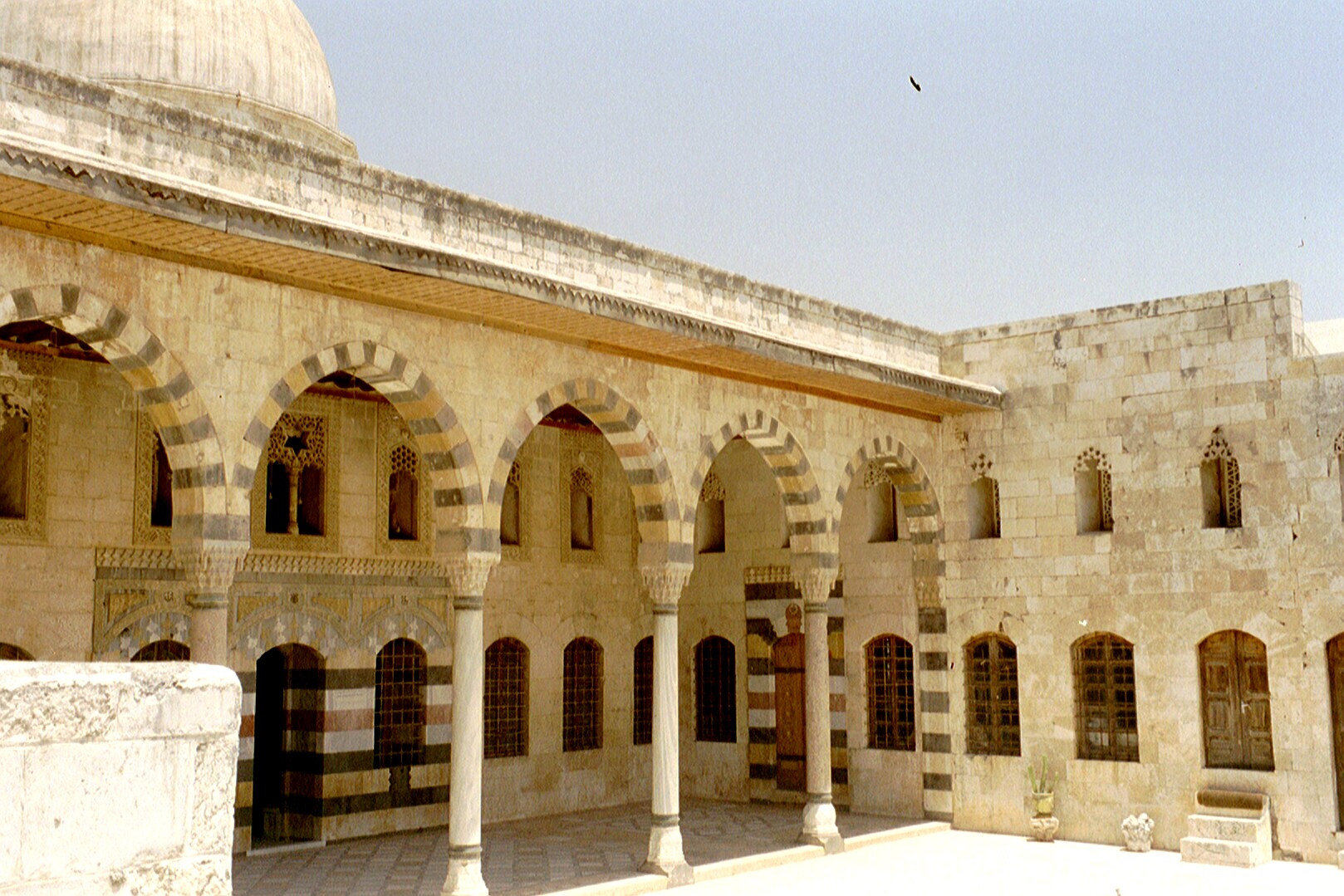
The Azem Palace in Hama was built in 1742
The prosperous period of Mamluk rule came to an end in 1516, when the Ottoman Turks conquered Syria from the Mamluks after defeating them at the Battle of Marj Dabiq near Aleppo. Hama, and the rest of Syria, came under Ottoman rule from Constantinople.[17] Under the Ottomans, Hama gradually became more important in the administrative structure of the region. It was first made capital of one of the liwas ("districts") of the vilayet ("province") of Tripoli.[9] Hama once again became an important center for trade routes running east from the Mediterranean coast into Asia. A number of khans ("caravansaries"s) were built in the city, like Khan Rustum Pasha which dates from 1556. Syria was later divided into three governorships and Hama was ruled by the governorship based at Aleppo.[17]
Then in the 18th century, it became apart of the holdings of the governor of Damascus.[9] The governors of Damascus at this time were the Azems, who also ruled other parts of Syria, for the Ottomans. They erected sumptuous residences in Hama, including the Azem Palace and Khan As'ad Pasha which were built by As'ad Pasha al-Azem, who governed Hama for a number of years until 1742.[17] By then, there were 14 caravansaries in the city, mostly used for the storage and distribution of seeds, cotton, wool, and other commodities.[18] After the passing of the Vilayet Law in 1864, Hama became the capital of the Sanjak of Hama (gaining the city more administrative powers), part of the larger vilayet of Sham.[9]
Modern era
Ottoman rule ended in 1917 after their defeat in World War I to the Allied Forces. Hama was made part of the French Mandate of Syria. By then, Hama had developed into what it has remained: a medium-sized provincial town, important as the market for an agricultural area abundant in cereals, but also cotton and sugar beets. It gained notoriety as the center of large estates worked by peasants and dominated by a few magnate families. During the French Mandate, the district of Hama contained within its bounds the municipality of Hama and 114 villages. By an estimate in 1930, only four of these villages were owned outright by local cultivators, while sharing ownership of two villages with a notable family. Thus, the hinterland was owned by landowning elites.[19]
Starting in the late 1940s, significant class conflict erupted agricultural workers sought reform Hama. Syria gained full independence from France in 1946. Akram al-Hawrani, a member of an impoverished notable family in Hama began to agitate for land reform and better social conditions. He made Hama the base of his Arab Socialist Party which later merged with another socialist party, the Ba'ath. This party's ascent to power in 1963 signaled the end of power for the landowning elite. In the spring of 1964, Hama became the epicenter of a revolt by conservative forces encouraged by speeches from mosque preachers denouncing the policies of the Ba'ath. The Syrian government sent tanks and troops into the quarters of Hama's old city to put down the insurrection.[19]
Political insurgency by Sunni Islamic groups, particularly the Muslim Brotherhood, occurred in the city, which was reputed as a stronghold of conservative Sunni Islam. In 1964, riots caused several tens of dead, and in the late 1970s, Hama became a major source of opposition to the regime during the Sunni Islamist uprising that began in 1976. In Spring 1982, Government forces led by the president's brother, Rifaat al-Assad, quelled the revolt with very harsh means. Tanks and artillery shelled the neighbourhoods held by the insurgents indiscriminately, and government forces are alleged to have executed thousands of prisoners and civilian residents after subduing the revolt. This became known as the Hama massacre. In the clean-up operations after the end of the fighting, large districts of the city, including most of the Old City, were levelled by bulldozers and later rebuilt, permanently changing the face of the city. Deaths in the Hama massacre have been estimated to range between 5000 to 20,000, with no reliable figures available. (Regime opponents, particularly the Muslim Brotherhood, claim figures are as high as 30,000 or 40,000.) The story is suppressed and regarded as highly sensitive in Syria.
Demographics
According to Josiah C. Russel, during the 12th century, Hama had a population of 6,750.[20] In 1932, while Hama was under the French Mandate, there approximately 50,000 residents. In the 1960 census, there were 110,000 inhabitants. The population continued to rise, reaching 180,000 in 1978 and 273,000 in 1994.[21] The infant mortality rate per 1,000 live births in the Hama Governorate was 99.4%.[22] A 2005 estimate had Hama's population at around 325,000 inhabitants.[23]
Most of the residents are Sunni Muslims, although some districts of the city are exclusively Christian.[23] Hama is reputed to be the most conservative Sunni Muslim city in Syria since French Mandate times. During that period there was an old saying reflecting this characteristic: "In Damascus, it takes only three men to make a political demonstration, while in Hama it takes only three men to get the town to pray."[19] The Christian population mostly adheres to the Greek Orthodox Church or the Syriac Orthodox Church.[24]
Ecclesiastical status


Greek Orthodox church
The Greek Orthodox Church has a bishopric in Hama governed by the Patriarch of Antioch.[24] Hama is still a Roman Catholic titular see (referred to as "Hamath" or Amath"), suffragan of Apamea. It is as "Epiphania" that it is best known in ecclesiastical documents. Lequien mentions nine Greek bishops of Epiphania.[25] The first of them, whom he calls Mauritius, is the Manikeios whose signature appears in the First Council of Nicaea.[26] Currently, it has two Catholic archbishops, a Greek Melkite and a Syrian, the former residing at Labroud, the latter at Hims, reuniting the titles of Hims (Emesus) and Hamah.[27]
Main sights

The Orontes River and 3 norias
Hama's most famous attractions are its 17 norias, dating back to the Byzantine times. Fed by the Orontes river, they are up to 20 metres (66 ft) in diameter. The largest norias are the al-Mamunye (1453) and the al-Muhammediye (14th century). Originally they were used to route water into aqueducts, which led into the town and the neighbouring agricultural areas.
Other sights include:
- the museum, housed in a 18th century Ottoman governor residence (Azem Palace). Remains in the exhibition include a precious Roman mosaic from the nearby village of Mariamin (4th century AD)
- al-Nuri mosque, finished in 1163 by Nur ad-Din after the earthquake of 1157. Notable is the minaret.
- The small Mamluk al-Izzi mosque (15th century)
- The mosque and Mausoleum of Abu al-Fida, a celebrated Arab historian who was also governor of the city.
- al-Hasanain mosque, also rebuilt by Nur ad-Din after the aforementioned earthquake.
- The Great Mosque. Destroyed in the 1982 bombardment, it has been rebuilt in its original forms. It has elements dating from the ancient and Christian structures existing in the same location. It has two minarets, and is preceded by a portico with an elevated treasury.
See also
 |
|
| Sound of a noria | |
|
|
|
| Sound of a noria | |
| Problems listening to this file? See media help. | |
- Hama massacre
References
- ↑ 1.0 1.1 1.2 1.3 1.4 1.5 Ring, 1996, p.315.
- ↑ Hamath's history from the inscriptions was encapsulated by George L. Robinson, "The Entrance of Hamath" The Biblical World 32.1 (July 1908:7-18), in discussing the topography evoked by the Biblical phrase "the entrance of Hamath".
- ↑ The ivories were found at Nimrud by Layard; one of the ivory panels found at "Fort Shalmaneser" is inscribed "Hamath" (R. D. Barnett, "Hamath and Nimrud: Shell Fragments from Hamath and the Provenance of the Nimrud Ivories" Iraq 25.1 [Spring 1963:81-85]).
- ↑ "Hamath Wrecked to Terrify Small Opponents of Assyria" The Science News-Letter 39.13 (March 29, 1941:205-206).
- ↑ Isaiah 10:9.
- ↑ 6.0 6.1 6.2 6.3 6.4 6.5 6.6 Ring, 1996, p.317.
- ↑ 1 Kings 4:21-24; 2 Chronicles 8:4.
- ↑ Room, Adrian. Placenames of the World. London: MacFarland and Company, Inc., 1997.
- ↑ 9.00 9.01 9.02 9.03 9.04 9.05 9.06 9.07 9.08 9.09 9.10 Dumper, Stanley, and Abu-Lughod, 2007, p.163.
- ↑ le Strange, 1890, p.39.
- ↑ le Strange, 1890, p.357.
- ↑ Robinson 1908:9.
- ↑ Nur al-Din Mosque. Archnet Digital Library.
- ↑ le Strange, 1890, p.359.
- ↑ 15.0 15.1 le Strange, 1890, p.360.
- ↑ le Strange, 1890, p.xxiii.
- ↑ 17.0 17.1 17.2 Ring, 1996, p.318.
- ↑ Reilly, 2002, p.72.
- ↑ 19.0 19.1 19.2 Dumper, Stanley, and Abu-Lughod, 2007, p.164.
- ↑ Shatzmiller, 1994, p.59.
- ↑ Wincler, 1998, p.72.
- ↑ Wincler, 1998, p.44.
- ↑ 23.0 23.1 Dumper, Stanley, and Abu-Lughod, 2007, p.162.
- ↑ 24.0 24.1 Schaff and Herzog, 1911, p.232.
- ↑ Oriens Christianus, II, pp.915-918.
- ↑ Gelzer, Heinrich, Patrum Nicaenorum Nomina. p.lxi.
- ↑ Missiones Catholicae. pp.781-804.
Bibliography
- This article incorporates text from the Catholic Encyclopedia of 1913, a publication now in the public domain. [1]
- Dumper, Michael; Stanley, Bruce E.; Abu-Lughod, Janet L. (2007), Cities of the Middle East and North Africa: A Historical Encyclopedia, ABC-CLIO, ISBN 1576079198, 9781576079195, http://books.google.com/books?id=3SapTk5iGDkC&printsec=frontcover&dq=Cities+of+the+Middle+East#PPA156,M1.
- Herzog, Johann Jakob; Schaff, Phillip (1911), The new Schaff-Herzog encyclopedia of religious knowledge: embracing Biblical, historical, doctrinal, and practical theology and Biblical, theological, and ecclesiastical biography from the earliest times to the present day, Funk and Wagnalls Company, http://books.google.com/books?id=amYAAAAAMAAJ&pg=PA232&dq=Hamah+Christian+population&lr=&ei=V1thSomtGo22yQSV2vW0DQ.
- Reilly, James (2002), A small town in Syria: Ottoman Hama in the eighteenth and nineteenth centuries, P. Lang, ISBN 390676690X, 9783906766904.
- Ring, Trudy; Berney, K.A.; Salkin, Robert M.; La Boda, Sharon; Watson, Noelle; Schellinger, Paul (1996), International Dictionary of Historic Places: Middle East and Africa, Routledge, ISBN 1884964036, http://books.google.com/books?id=R44VRnNCzAYC.
- Shatzmiller, Maya (1994), Labour in the medieval Islamic world, BRILL, ISBN 9004098968, 9789004098961, http://books.google.com/books?id=Bzo0Skd1kcYC&pg=PA65&dq=Population+of+Egypt+Ayyubid&ei=6f9KStSRF5iCyATf2s2cDg.
- le Strange, Guy (1890), Palestine Under the Moslems: A Description of Syria and the Holy Land from A.D. 650 to 1500, Committee of the Palestine Exploration Fund, http://books.google.com/books?id=ENANAAAAIAAJ&pg=PA493&dq=Lajjun+Guy+le+Strange&lr=&ei=-0MmScyML4TkygTn-J2KAg#PPP1,M1.
- Winckler, Onn (1998). Demographic developments and population policies in Baʻathist Syria. Sussex Academic Press. ISBN 1902210166. http://books.google.com/books?id=ki6yXV0qxw4C&pg=PA71&dq=Hama+Syria&lr=&ei=vodgSv-wBJTklATwyaQ5..
External links
- Some or all of this article is forked from Wikipedia. The original article was at Hama. The list of authors can be seen in the page history.
- E.sy Governmental online services
- Official site of Hama governorate (in Arabic)
- Hama city community on the net (in Arabic)
Further reading
- P. J. Riis/V. Poulsen, Hama: fouilles et recherches 1931-1938 (Copenhagen 1957).
Coordinates: 35°08′N 36°45′E / 35.133°N 36.75°E Template:Cities of Syria
ar:حماة
br:Hama
ca:Hamat
cy:Hama
eo:Hamao
fa:حمات
is:Hama
la:Epiphania (Syria)
ja:ハマー (都市)
no:Hamat
pt:Hama
ro:Hama
ru:Хама
sl:Hama
sh:Hama
fi:Hama
sv:Hamah
tg:Вилояти Ҳамоҳ
tr:Hama
ur:حماہ