
| Part of the series on the Israeli West Bank barrier | |
|---|---|
 | |
| contents | |
| About | |
| Overview | |
| Effects and consequences | |
| Legal Status | |
| Opinions on the barrier | |
| External links and resources | |
| Portal:Israel-Palestine | |
Overview[]
Names of the barrier[]
The naming of the barrier is controversial. Israelis most commonly refer to the barrier as the "separation (hafrada) fence", Geder HaHafrada) and "security fence" or "anti-terrorist fence", with "seam zone" (קו התפר, Kav HaTefer) referring to the land between the fence and the 1949 armistice lines.
Palestinians most commonly refer to the barrier in Arabic as, (racial segregation wall), and some opponents of the barrier refer to it in English as the "Apartheid Wall."
The International Court of Justice, in its advisory opinion on the barrier, wrote it had chosen to use the term "wall" "the other expressions sometimes employed are no more accurate if understood in the physical sense."
The BBC's style guide for journalists states "The BBC uses the terms barrier, separation barrier or West Bank barrier as acceptable generic descriptions to avoid the political connotations of "security fence" (preferred by the Israeli government) or "apartheid wall" (preferred by the Palestinians)."
History and stated purpose[]
The idea of creating a physical barrier between the Israeli and Palestinian populations was first proposed by in 1992 by then-prime minister Yitzhak Rabin, following the murder of an Israeli teenage girl in Jerusalem. Rabin said that Israel must "take Gaza out of Tel Aviv", in order to minimize friction between the peoples.
Government action[]
Although the government of Prime Minister Ariel Sharon was initially hesitant to construct the barrier, he finally embraced the plan. The stated purpose of the barrier is to prevent terrorists from entering Israeli cities, a problem which has plagued Israel since the start of the Second Intifada. A secondary stated purpose of the barrier is to prevent infiltration by Palestinians for economic reasons. The Israeli government says that the high concrete portions are to protect cars and people on the Israeli side from gunfire.

According to Natan Sharansky, Minister of Housing and Construction at the time:
When Israel's free society was defending itself against an unprecedented campaign of terror, most of the international community was calling for an end of the "cycle of violence" and a return to the negotiating table. When the Palestinian terrorists struck... Israel was condemned for imposing "collective punishment" on the Palestinian population. When Israel chose to target individual terrorists with precision air strikes, its actions were condemned as illegal extrajudicial assassinations. It seemed that in eyes of many, the Jews had a right to defend themselves in theory but could not exercise that right in practice... our government understood that there were three options to maintain an acceptable level of security for our citizens. The first was to wage a total war against Palestinian terror using weapons that would claim many innocent Palestinian lives. The second was to keep our reserves constantly mobilized to defend the country. The third option was to build the security fence. Had the Palestinian Authority become a partner in fighting terror, as it was obliged to do under all the agreements that it signed, none of these options would have become necessary.
Route and route timeline[]
The barrier generally runs along or near the 1949 Jordanian-Israeli armistice/Green Line, but diverges in many places to include on the Israeli side several of the highly populated areas of Israeli settlements in the West Bank such as East Jerusalem, Ariel, Gush Etzion, Emmanuel, Karnei Shomron, Givat Ze'ev, Oranit, and [[Maale Adumim Most of the barrier is actually set in the West Bank It diverges from the "Green Line" by anywhere from 200 meters to as much as 20 kilometers, with the result that many Israeli settlements in the West Bank remain on the Israeli side of the barrier, and some Palestinian towns are nearly encircled by it. Approximately 20% is actually on the Green Line The proponents of the barrier claim that its route is not set in stone, as it was challenged in court and changed several times. They note that the cease-fire line of 1949 was negotiated "without prejudice to future territorial settlements or boundary lines" (Art. VI.9) Security experts argue that the topography does not permit putting the barrier along the Green Line in some places, because hills or tall buildings on the Palestinian side would make the barrier ineffective against terrorism The International Court of Justice has countered that in such cases it is only legal to build the barrier inside Israel. , the barrier extends inside most of the northwestern and western edges of the West Bank, sometimes close to the Green Line, and sometimes running further east. In some places there are also secondary barriers, creating a number of completely enclosed enclaves.


In February 2004, the Israeli government said it would review the route of the barrier in response to US and Palestinian concerns. In particular, Israeli cabinet members said modifications would be made to reduce the number of checkpoints Palestinians had to cross, and especially to reduce Palestinian hardship in areas such as Qalqilyah where the barrier goes very near, and in some cases nearly encircles, populated areas.
On June 30, 2004, the Supreme Court of Israel ruled that a portion of the barrier west of Jerusalem violates the rights of Palestinians, and ordered 30 km of existing and planned barrier to be rerouted. However, it did rule that the barrier is legal in essence and accepted the Israeli government's claim that it is a security measure. On July 9, 2004, the International Court of Justice issued an advisory opinion that it is a violation of international law. At the beginning of September 2004, Israel started the southern part of the barrier.

On February 20, 2005, the Israeli cabinet approved a new route. The new route was 681 kilometers and would leave approximately seven percent of the West Bank and 10,000 Palestinians on
the Israeli side. (Map) Before that time, the exact route of the barrier had not been finalized, and it had been alleged by opponents that the barrier route would encircle the Samarian highlands of the West Bank, separating them from the Jordan valley.[1]
Following a suicide bombing in Tel Aviv, the route was again revised by a cabinet decision on April 30, 2006.[2][3][4] In the Ariel area, the new route corrects an anomaly of the previous route that would have left thousands of Palestinians on the Israeli side. The Alfei Menashe settlement bloc was reduced in size, and the new plan leaves three groups of Palestinian houses on the Palestinian side of the fence. The barrier's route in the Jerusalem area will leave Beit Iksa on the Palestinian side; and Jaba on the Israeli side, but with a crossing to the Palestinian side at Tzurif. Further changes were made to the route around Eshkolot and Metzadot Yehuda, and the route from Metzadot to Har Choled was approved.[5]
According to the current route, 8.5 percent of the West Bank territory and 27,520 Palestinians are on the "Israeli" side of the barrier. Another 3.4 percent of the area (with 247,800 inhabitants) is completely or partially surrounded by the barrier.
Structure[]
Most of the barrier (over 95% of total length) consists of a "multi-layered fence system"[6] ideally 50 m in width. The IDF's preferred design has three fences, with pyramid-shaped stacks of barbed wire for the two outer fences and a lighter-weight fence with intrusion detection equipment in the middle. Patrol roads are provided on both sides of the middle fence, an anti-vehicle ditch is located on the West Bank side of the fence, and a smooth dirt strip on the Israeli side for "intrusion tracking".
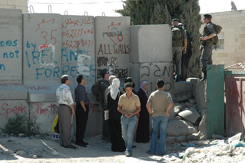
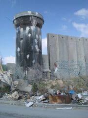
Some sections (less than 5% of total length) are constructed as a wall made up of concrete slabs up to 8 m in height and 3 m in width. Occasionally, due to topographic conditions other sections of the barrier will reach up to 100 m in width.[7] Wall construction (5%) is more common in urban settings, such as areas near Qalqilyah and Jerusalem, because it is narrower, requires less land, and provides more protection against snipers. In all cases there are regular observation posts, automated sensing devices and other apparatuses. Gates at various points are controlled by Israeli soldiers.
References[]
- ↑ [1]
- ↑ JURIST - Paper Chase: Israel cabinet approves changes to security fence route
- ↑ Seam zone map
- ↑ Barrier overview July 2006
- ↑ Israel Security Fence - Ministry of Defense
- ↑ "OPERATIONAL CONCEPT". The State of Israel. 2007-01-31. http://www.securityfence.mod.gov.il/Pages/ENG/operational.htm. Retrieved 2008-03-15. "Solid barrier system ... main purpose is to prevent sniper fire into Israel and on major highways and roads. In this case, a solid concrete wall resembling a highway sound barrier often used in the US and Europe is erected. Once the whole project is completed, the portion of the concrete sections will be 6%, approximately 30 km."
- ↑ Researched and written by Yehezkel Lein (April 2003). "Behind The Barrier : Human Rights Violations As a Result of Israel's Separation Barrier" (PDF). B'Tselem. http://www.nad-plo.org/palisraeli/wall/related/bwall.pdf. Retrieved 2008-03-15. "The average width of the barrier complex is sixty meters. Due to topographic constraints, a narrower barrier will be erected in some areas and will not include all of the elements that support the electronic fence. However, as the state indicated to the High Court of Justice, “in certain cases, the barrier will reach a width of one hundred meters due to the topographic conditions.”"