Coordinates: Template:FraAbbr_type:city(41) 48°38′10″N 1°30′41″W / 48.636028°N 1.511393°W
Template:Infobox French commune/regdept|
Le Mont-Saint-Michel | |

| |
| Le Mont-Saint-Michel. | |

| |
| Le Mont-Saint-Michel#Héraldique | |
[[image:Template:Location map France|270px|Le Mont-Saint-Michel is located in Template:Location map France]] <div style="position: absolute; z-index: 2; top: Expression error: Unrecognized punctuation character "[".%; left: Expression error: Unrecognized punctuation character "[".%; height: 0; width: 0; margin: 0; padding: 0;"> Le Mont-Saint-Michel | |
| Template:Infobox French commune/regmap | |
| Administration | |
|---|---|
| Country | France |
| Arrondissement | Avranches |
| Canton | Pontorson |
| Intercommunality | Communauté de communes de Pontorson - Le Mont-Saint-Michel |
| Mayor | Éric Vannier (2008–2014) |
| Statistics | |
| Elevation | 5–80 m (16–260 ft) |
| Land area1 | 0.97 km2 (0.37 sq mi) |
| Population2 | 41 (2006) |
| - Density | 42 /km2 (110 /sq mi) |
| INSEE/Postal code | 50353/ 50116 |
| 1 French Land Register data, which excludes lakes, ponds, glaciers > 1 km² (0.386 sq mi or 247 acres) and river estuaries. | |
| 2 Population sans doubles comptes: residents of multiple communes (e.g., students and military personnel) only counted once. | |
| Mont-Saint-Michel and its Bay* | |
|---|---|
| UNESCO World Heritage Site | |
|
| |
| State Party | Template:FRA |
| Type | Cultural |
| Criteria | i, iii, vi |
| Reference | 80 |
| Region** | Europe |
| Inscription history | |
| Inscription | 1979 (3rd Session) |
| * Name as inscribed on World Heritage List. ** Region as classified by UNESCO. | |
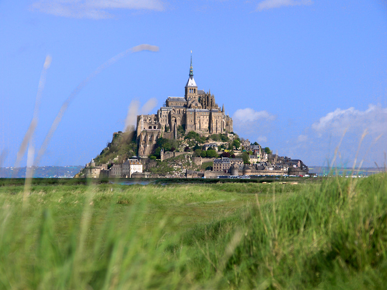
Le Mont-Saint-Michel (English: Saint Michael's Mount) is a rocky tidal island and a commune in Normandy, France. It is located approximately one kilometre off the country's north coast, at the mouth of the Couesnon River near Avranches. The population of the island is 41.
Formation[]
In prehistoric times the bay was land. As sea levels rose erosion shaped the coastal landscape over millions of years. Several blocks of granite or granulite emerged in the bay, having resisted the wear and tear of the ocean better than the surrounding rocks. These included Lillemer, the Mont-Dol, Tombelaine and Mont Tombe, later called Mont-Saint-Michel.
Tidal island[]


Mont-Saint-Michel seen from Spot Satellite
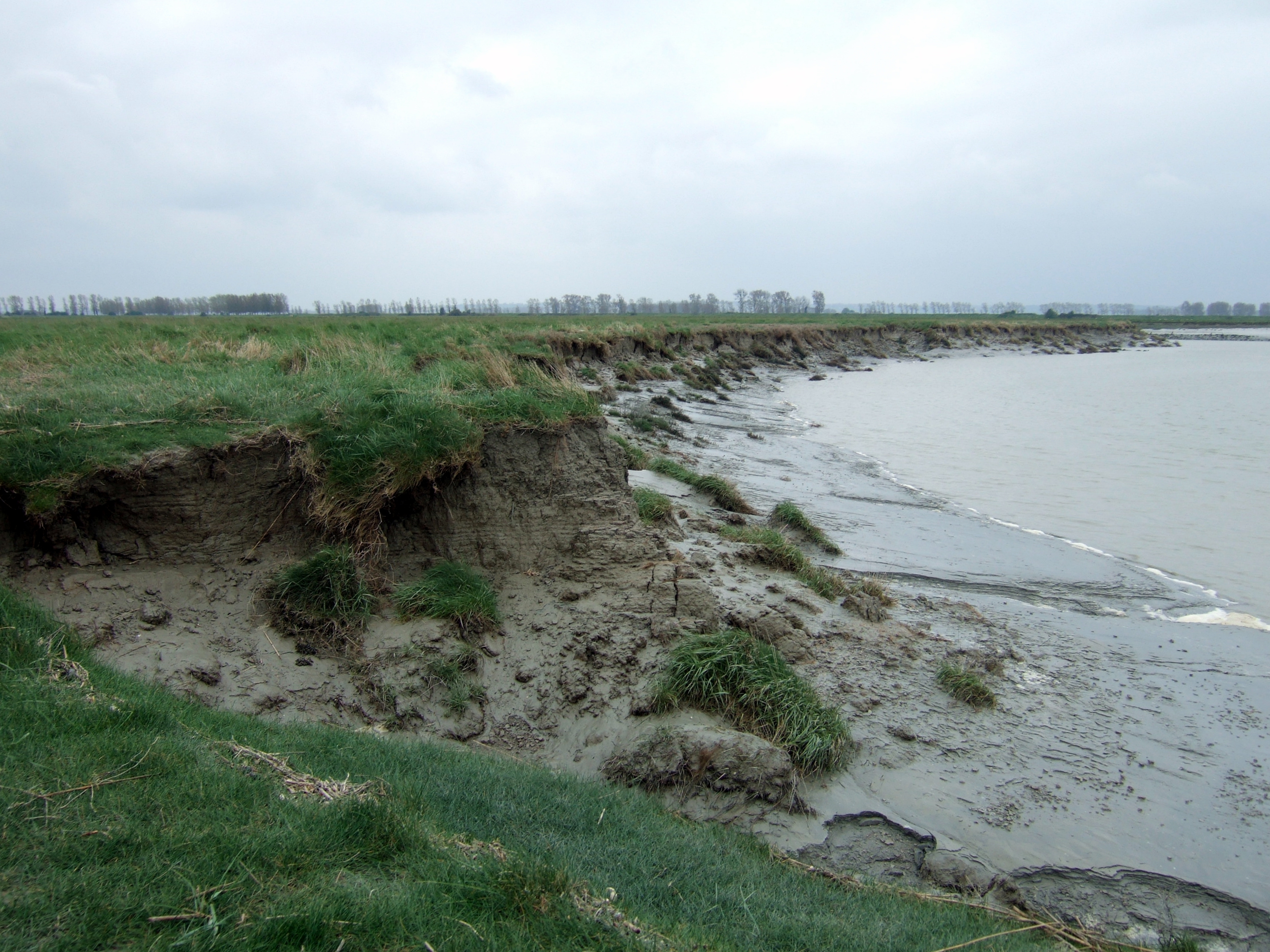
Mont-Saint-Michel was previously connected to the mainland via a thin natural land bridge, which before modernization was covered at high tide and revealed at low tide. This has been compromised by several developments. Over the centuries, the coastal flats have been polderised to create pasture. Thus the distance between the shore and the south coast of Mont-Saint-Michel has decreased. The Couesnon River has been canalised, reducing the flow of water and thereby encouraging a silting-up of the bay. In 1879, the land bridge was fortified into a true causeway. This prevented the tide from scouring the silt round the mount.


At low tide surrounded by mud flats - seen from the air
On 16 June 2006, the French prime minister and regional authorities announced a €164 million project (Projet Mont-Saint-Michel[1]) to build a hydraulic dam using the waters of the river Couesnon and of tides that will help remove the accumulated silt deposited by the uprising tides, and to make Mont-Saint-Michel an island again. It is expected to be completed by 2012.[2]
The construction of the dam is now complete (it was inaugurated in 2009). The project also includes the destruction of the causeway that was built on top of the small land bridge and enlarged, to join the island to the continent, but also used as a parking for visitors. It will be replaced by an elevated light bridge, under which the waters will flow more freely, and that will improve the efficiency of the now operational dam, and the construction of another parking on the continent. Visitors will have to use small shuttles to cross the future bridge which will still be open to walking people and unmotorized cycles.
History[]


Mont-Saint-Michel from the south

Mont-Saint Michel
Mont-Saint-Michel was used in the sixth and seventh centuries as an Armorican stronghold of Romano-Breton culture and power, until it was ransacked by the Franks, thus ending the trans-channel culture that had stood since the departure of the Romans in AD 460.


Mont-Saint-Michel Abbey, albumen print, ca. 1865-1895
Before the construction of the first monastic establishment in the 8th century, the island was called "monte tombe". According to legend, St. Michael the Archangel appeared to St. Aubert, bishop of Avranches, in 708 and instructed him to build a church on the rocky islet. Aubert repeatedly ignored the angel's instruction, until St. Michael burned a hole in the bishop's skull with his finger.[3]
The mount gained strategic significance in 933 when William "Long Sword", William I, Duke of Normandy, annexed the Cotentin Peninsula, definitively placing the mount in Normandy. It is depicted in the Bayeux Tapestry, which commemorates the 1066 Norman conquest of England. Ducal patronage financed the spectacular Norman architecture of the abbey in subsequent centuries.
In 1067, the monastery of Mont-Saint-Michel gave its support to duke William of Normandy in his claim to the throne of England. It was rewarded with properties and grounds on the English side of the Channel, including a small island located at the west of Cornwall, which, modelled after the Mount, became a Norman priory named St Michael's Mount of Penzance.
During the Hundred Years' War the English made repeated assaults on the island but were unable to seize it due to the abbey's improved fortifications. Les Michelettes, two wrought-iron bombards left by the English in their failed 1423–24 siege of Mont-Saint-Michel, are still displayed near the outer defense wall.
When Louis XI of France founded the Order of Saint Michael in 1496 he intended that the abbey church of Mont Saint-Michel be the chapel for the order, but because of its great distance from Paris his intention could never be realized.


Some of the old buildings in the village
The wealth and influence of the abbey extended to many daughter foundations, including St Michael's Mount in Cornwall. However, its popularity and prestige as a centre of pilgrimage waned with the Reformation, and by the time of the French Revolution there were scarcely any monks in residence. The abbey was closed and converted into a prison, initially to hold clerical opponents of the republican régime. High-profile political prisoners followed, but by 1836 influential figures, including Victor Hugo, had launched a campaign to restore what was seen as a national architectural treasure. The prison was finally closed in 1863, and the mount was declared a historic monument in 1874. The Mont-Saint-Michel and its bay were added to the UNESCO list of World Heritage Sites in 1979, as it was listed with criteria such as cultural, historical, and architectural significance, as well as human-created and natural beauty.[4]
Development[]
")
")
")
")
Heraldry[]
Template:Blazon-arms
Design[]


Plan of the mount by Eugène Viollet-le-Duc
William de Volpiano, the Italian architect who had built the Abbey of Fécamp in Normandy, was chosen as building contractor by Richard II of Normandy in the 11th century. He designed the Romanesque church of the abbey, daringly placing the transept crossing at the top of the mount. Many underground crypts and chapels had to be built to compensate for this weight; these formed the basis for the supportive upward structure that can be seen today. Today Mont-Saint-Michel is seen as a Gothic-style church.
Robert de Thorigny, a great supporter of Henry II of England (who was also Duke of Normandy), reinforced the structure of the buildings and built the main façade of the church in the 12th century. In 1204 the Breton Guy de Thouars, allied to the King of France, undertook the siege of the Mount. After having set fire to the village and having massacred the population, he was obliged to beat a retreat under the powerful walls of the abbey. Unfortunately, the fire which he himself lit extended to the buildings, and the roofs fell prey to the flames. Horrified by the cruelty and the exactions of his Breton ally, Philip Augustus offered Abbot Jourdain a grant for the construction of a new Gothic-style architectural set which included the addition of the refectory and cloister.
Charles VI is credited with adding major fortifications to the abbey-mount, building towers, successive courtyards and strengthening the ramparts.
Tides[]

Thick mud is exposed on the banks of the river Couesnon at low tide.
The tides in the area change quickly, and have been described by Victor Hugo as "à la vitesse d'un cheval au galop" or "as swiftly as a galloping horse".
The tides can vary greatly, at roughly 14 metres between high and low water marks. Popularly nicknamed "St. Michael in peril of the sea" by medieval pilgrims making their way across the flats, the mount can still pose dangers for visitors who avoid the causeway and attempt the hazardous walk across the sands from the neighbouring coast.
Polderisation and occasional flooding created salt marsh meadows that were found to be ideally suited to grazing sheep. The well-flavoured meat that results from the diet of the sheep in the pré salé (salt meadow) makes agneau de pré-salé (salt meadow lamb), a local specialty that may be found on the menus of restaurants that depend on income from the many visitors to the mount.
Administration[]


The cloister
The islet belongs to the French commune of Le Mont-Saint-Michel, of the Manche département, in the Basse-Normandie région. Population (1999): 50. The nearest major town, with an SNCF train station, is Pontorson. Mont-Saint-Michel belongs to the Organization of World Heritage Cities.
The Mont-Saint-Michel has also been the subject of traditional, but nowadays good-humoured, rivalry between Normans and Bretons. Bretons claim that, since the Couesnon River marks the traditional boundary between Normandy and Brittany, it is only because the river has altered its course over the centuries that the mount is on the Norman side of the frontier. This legend amuses the frontier inhabitants who know that the border is not located on the Couesnon river itself but on the mainland at 4 km in the west, at the foot of the solid mass of Saint-Brelade.
Mont-Saint-Michel in modern culture[]
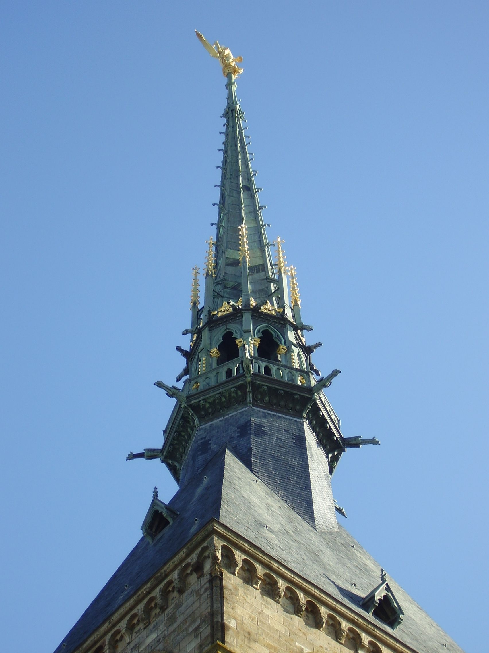

Statue of Archangel Michael atop the spire
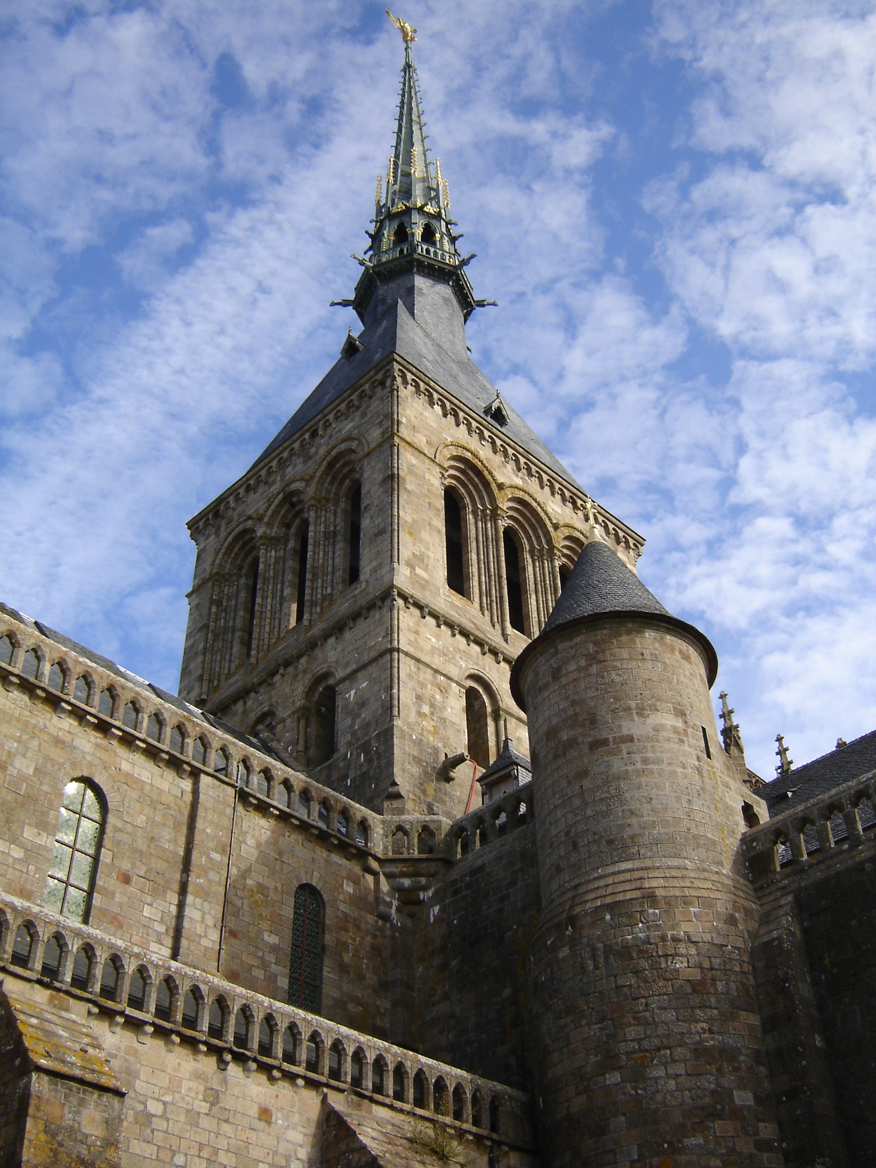

The spire of Mont-Saint-Michel is visible from the courtyard outside the abbey.


The entrance to the abbey of Mont-Saint-Michel leading out into the courtyard in front of the abbey.
- Mont-Saint-Michel is featured in the 1950 Powell and Pressburger film The Elusive Pimpernel.[5]
- Mont-Saint-Michel and the ancient forest of Quokelunde are plot devices in the 1955 book for young readers, The Mystery Of Mont Saint-Michel by Michel Rouzé, translated by George Libaire; Henry Holt and Company - New York - 1955 (The original 1953 French novel: Le Forêt de Quokelunde; Editions Bourrelier - Paris - 1953)
- The Mont-Saint-Michel was featured in the 1985 IMAX film Chronos, in which an aerial view of the incoming tides are shown using time lapse video.
- The 1990 Bernt Amadeus Capra film Mindwalk was filmed on the mount.
- Mike Oldfield composed instrumental track dedicated to the Mont-Saint-Michel and released it on the Voyager album in 1996.
- Cornish electronic music artist Aphex Twin released a song entitled "Mt Saint Michel + Saint Michaels Mount".
- The castle was featured in the Disneyland Paris ride The Timekeeper.
- The Mont was featured in Impressions de France, a movie shown at Epcot in Orlando, Florida.
- Mont-Saint-Michel was also featured in a scene in the 2004 animated Disney movie Mickey, Donald, Goofy: The Three Musketeers, in which Captain Pete of the Musketeers attempted to drown Mickey Mouse in order to carry out his plot to take over France's monarchy as king without interruption. Pete even mentions it by name, telling Mickey before leaving the dungeon, "Enjoy your stay at the Mont Saint-Michel—they say the tide comes in faster than horses!" This is in reference to the cathedral's history as a jail for political prisoners, as well as Victor Hugo's description of the tides.
- According to the Making Of featurettes on the Extended Edition DVDs, the Mont-Saint-Michel, was an inspiration for the design of Minas Tirith in the 2003 film The Lord of the Rings: The Return of the King, directed by Peter Jackson.
- The Mont-Saint-Michel was featured in Onimusha 3: Demon Siege. The Genma had taken control of it and used it to house the time folder. The Mont-Saint-Michel was destroyed after the time folder exploded.
- The location, including the tidal speed, is featured in Sharon Kay Penman's medieval mystery, Prince of Darkness.
- In Bernard Cornwell's book The Winter King, the island is given the name Ynys Trebes and is the capital of the Armorican kingdom of Benoic. The book also gives a fictionalized portrayal of its destruction by the Franks.
- In 1913, the American intellectual Henry Brooks Adams wrote Mont-Saint-Michel and Chartres[6], celebrating the unity of medieval society, especially as represented in the great cathedrals of France.
- In La promesse de l'ange, a novel by Frederic Lenoir and Violette Cabesos,[7] the main action takes place in the Mont-Saint-Michel.
- Appeared in the Roxette music video "Queen of Rain"
- French composer Claude Debussy frequented the island and possibly drew inspiration from not only the legend of the mythical city of Ys, but also Mont-Saint-Michel's cathedral for his piano prelude La Cathedrale Engloutie.[8]
- French author Maxime Chattam used the Mont-Saint-Michel as one of the main locations in his book Le Sang du Temps[9]
- Seen in the cover of Japanese musician Erika Sawajiri's debut single Free.
- Seen in the cover of the North American release of Castlevania: Symphony of the Night.
- Is referenced in Strike Witches, as their base of operations is an ornate castle that resembles Mont Saint-Michel.
- Mont-Saint-Michel is used as inspiration for the novelette "The Bloody Chamber" by Angela Carter.
Sister cities[]
 Hatsukaichi, Hiroshima, Japan - where the Itsukushima Shrine; an UNESCO World Heritage Site is located[10][11][12].
See also[]
- Manoir de Brion
- La Mère Poulard
- St Michael's Mount
- Archangel Michael: Roman Catholic traditions and views
- Itsukushima Shrine
References[]
- ↑ Projet Mont-Saint-Michel
- ↑ La Baie, June 2007, p.4, in French
- ↑ Catholic encyclopedia
- ↑ UNESCO
- ↑ The Elusive Pimpernel
- ↑ Adams, Henry (1905). Mont-Saint-Michel and Chartres. self-published. http://books.google.com/books?id=RYIRp86RIgEC.
- ↑ Lenoir, Frederic; Violette Cabesos (2004). La promesse de l'ange. Albin Michel. ISBN 9782226150811 (in French).
- ↑ Debussy's: La Cathedrale Engloutie
- ↑ Chattam, Maxime (2005). Le Sang du Temps. Michel Lafon. ISBN 9782749902524 (in French).
- ↑ Le Mont-Saint-Michel - Jumelage
- ↑ Nishihiroshima Times
- ↑ Miyajima Grand Hotel Info
External links[]
| Wikimedia Commons has media related to: Mont-Saint-Michel |
- Mont-Saint-Michel Celebrates 1,300 yrs of History
- Mont Saint-Michel travel guide from Wikitravel
- Official Mont-Saint Michel Tourist site (English version)
- The 150 year anniversary of France and Japan in 2008 in French
- Mont Saint-Michel Holiday Guide Getting there, the abbey and other tourist sites (English)
Template:World Heritage Sites in France Template:Manche communes
af:Mont-Saint-Michel ar:جبل القديس ميشيل bg:Мон Сен Мишел ca:Mont Saint-Michel cs:Mont-Saint-Michel da:Mont Saint-Michel eo:Monto Sankta Mikaelo eu:Mont Saint-Michel ko:몽생미셸 섬 hr:Mont-Saint-Michel id:Mont Saint-Michel is:Le Mont Saint Michel ka:მონ-სენ-მიშელი lt:Sen Mišelio kalnas hu:Mont-Saint-Michel ja:モン・サン=ミシェル no:Mont-Saint-Michel nn:Mont Saint-Michel nrm:Mont Saint Miché pms:Mont-Saint-Michel pt:Monte Saint-Michel ro:Mont Saint-Michel ru:Мон-Сен-Мишель simple:Mont Saint Michel sk:Mont-Saint-Michel sl:Mont Saint-Michel sr:Мон Сен Мишел sh:Mont-Saint- Michel fi:Mont Saint-Michel sv:Mont-Saint-Michel th:มงต์-แซงต์-มีแชล vec:Monte San Michełe vi:Mont-Saint-Michel vo:Le Mont-Saint-Michel zh:聖米歇爾山