| Bagan ပုဂံ formerly Pagan |
|
|---|---|
 |
|
[[image:Template:Location map Burma|250px|Bagan is located in Template:Location map Burma]] <div style="position: absolute; z-index: 2; top: Expression error: Unrecognized punctuation character "[".%; left: Expression error: Unrecognized punctuation character "[".%; height: 0; width: 0; margin: 0; padding: 0;"> [[Image:Template:Location map Burma|6x6px|link=|alt=]] Bagan |
|
| Coordinates: 21°10′N 94°53′E / 21.167°N 94.883°E | |
| Country | Burma (Myanmar) |
| Admin. division | Mandalay Division |
| Population | |
| - Ethnicities | Bamar |
| - Religions | Buddhism |
Bagan (Burmese: ပုဂံ; MLCTS: pu.gam, pronounced [pəɡàN]), formerly Pagan, is an ancient city in the Mandalay Division of Burma. Formally titled Arimaddanapura or Arimaddana (the City of the Enemy Crusher) and also known as Tambadipa (the Land of Copper) or Tassadessa (the Parched Land), it was the ancient capital of several ancient kingdoms in Burma. It is located in the dry central plains of the country, on the eastern bank of the Ayeyarwady River, 90 miles (145 km) southwest of Mandalay.
Bagan was submitted to become a UNESCO heritage site[1] but many speculate of politics as partly the reason for the exclusion. UNESCO does not designate Bagan as a World Heritage Site. The main reason given is that the military junta (SPDC) has haphazardly restored ancient stupas, temples and buildings, ignoring original architectural styles and using modern materials which bear little or no resemblance to the original designs. The junta has also established a golf course, a paved highway, and built a 200-foot (61-m) watchtower in the southeastern suburb of Minnanthu.[2]
Architectural styles[]
The religious buildings of Bagan are often reminiscent of popular architectural styles in the period of their constructions. The most common types are:
- Stupa with a relic-shaped dome
- Stupa with tomb-shaped dome
- Sinhalese-styled stupa
- North Indian model
- Central Indian model
- South Indian model
- Mon model
History[]


A view of Bagan
The ruins of Bagan cover an area of 16 square miles. The majority of its buildings were built in the 1000s to 1200s, during the time Bagan was the capital of the First Burmese Empire. It was not until King Pyinbya moved the capital to Bagan in AD 874 that it became a major city. However, in Burmese tradition, the capital shifted with each reign, and thus Bagan was once again abandoned until the reign of Anawrahta. In 1057, King Anawrahta conquered the Mon capital of Thaton, and brought back the Tripitaka Pali scriptures, Buddhist monks and craftsmen and all of these were made good use of in order to transform Bagan into a religious and cultural centre. With the help of a monk from Lower Burma, Anawrahta made Theravada Buddhism a kind of state religion, and the king also established contacts with Sri Lanka. In the 12th and 13th centuries, Bagan became a truly cosmopolitan centre of Buddhist studies, attracting monks and students from as far as India, Sri Lanka as well as the Thai and Khmer kingdoms. Among many other works, Aggavaṃsa's influential Saddanīti, a grammar of the language of the Tipiṭaka, would be completed there in 1154. In 1287, the kingdom fell to the Mongols, after refusing to pay tribute to Kublai Khan. Abandoned by the Burmese king and perhaps sacked by the Mongols, the city declined as a political centre, but continued to flourish as a place of Buddhist scholarship.
| Name | Relationship | Reign (AD) | Notes |
|---|---|---|---|
| Thamudarit | 107-152 | founder of Bagan† | |
| Pyinbya | Son of Khelu | 846-878 | moved capital from Tampawadi (modern Pwasaw) to Bagan |
| Anawrahta | Son of Kunsaw Kyaunghpyu | 1044-1077 | founder of Bagan and the First Burmese Empire† |
| Sawlu | Son | 1077-1084 | |
| Kyanzittha | Brother | 1084-1113 | |
| Alaungsithu | Grandson | 1113-1167 | 1113-1160(?) |
| Narathu | Son | 1167-1170 | 1160-1165(?), aka Kala-gya Min (king fallen by Indians) |
| Naratheinkha | Son | 1170-1173 | |
| Narapatisithu | Brother | 1174-1211 | |
| Htilominlo | Son | 1211-1234 | aka Nandaungmya (one who often asked for the throne) |
| Kyaswa | Son | 1234-1250 | |
| Uzana of Pagan | Son | 1250-1255 | |
| Narathihapate | Son | 1255-1287 | lost the kingdom to the Mongols and known as Tayoke Pyay Min (king who fled from the Chinese) to posterity |
| Kyawswa | Son | 1287-1298 | |
| Sawhnit | Son | 1298-1325 | |
| Sawmunnit | Son | 1325-1369 |
† Although Anawrahta is accounted for the founding of Bagan, Thamudarit is listed as the "traditional" founder of Bagan in The Glass Palace Chronicle (Hmannan Yazawin).
Cultural sites[]


The Payathonzu Temple is built in the Mon style.


Bagan at dawn, 1999.

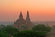
Bagan at sunrise, 1999.
- Ananda Temple, c.1090, built by Kyanzittha
- Bupaya Pagoda, c.850, demolished by the 1975 earthquake and completely rebuilt
- Dhammayangyi Temple, c.1165, the biggest temple in Bagan, built by Alaungsithu but never finished
- Dhammayazika Pagoda, 1196-98, built by Narapatisithu (Sithu II)
- Gawdawpalin Temple, started by Narapatisithu and finished by Nandaungmya, the superstructure destroyed by the 1975 quake and rebuilt
- Htilominlo Temple, 1218, built by Htilominlo
- Lawkananda Pagoda, built by Anawrahta
- Mahabodhi Temple, Bagan, c. 1218, a smaller replica of the temple in Bodh Gaya, India
- Manuha Temple, built by the captive Mon king Manuha
- Mingalazedi Pagoda, 1268-74, built by Narathihapate
- Myazedi inscription, c. 1113, described as the "Rosetta Stone of Burma" with inscriptions in four languages: Pyu, Mon, Old Burmese and Pali, dedicated to Gubyaukgyi Temple by Prince Rajakumar, son of Kyanzittha
- Nanpaya Temple, c.1060-70, Mon style, believed to be either Manuha's old residence or built on the site
- Nathlaung Kyaung Temple, mid 11th.C., Hindu deities "confined" to this temple
- Payathonzu Temple, probably around 1200
- Sein-nyet Ama & Nyima (temple and pagoda, 13th century)
- Shwegugyi Temple, 1131, built by Alaungsithu and where he died
- Shwesandaw Pagoda, c.1070, built by Anawrahta
- Shwezigon Pagoda, 1102, built by Anawrahta, finished by Kyanzittha
- Sulamani Temple, 1183, built by Narapatisithu
- Tan-chi-daung Paya, on the west bank, built by Anawrahta
- Tharabha Gate, c.850, built by King Pyinbya
- Thatbyinnyu Temple, the tallest temple at 200 feet (61 m), 12th century, built by Alaungsithu
- Tu-ywin-daung Paya, on the eastern boundary of Bagan, built by Anawrahta
Neighbours[]
- Thaton (to the south, in modern-day Burma) until subdued in 1057
- Nanzhao (to the north, in modern-day Yunnan Province, China)
Sister cities[]
- Template:Country data Laos Luang Prabang
- Template:Country data Cambodia Siem Reap, Cambodia[1]
")
")
")
See also[]
- Buddhism in Burma
- Culture of Burma
- History of Buddhism
- Nyaung U Airport
References[]
- ↑ http://whc.unesco.org/en/tentativelists/819/
- ↑ Tourtellot, Jonathan (2004-09-03). "Dictators "Defacing" Famed Burma Temples, Editor Says". National Geographic Traveler. http://news.nationalgeographic.com/news/2004/09/0903_040903_travelwatch.html. Retrieved 2006-05-27.
- Pictorial Guide to Pagan. 2nd ed. Rangoon: Ministry of Culture, 1975.
- Pagan - Art and Architecture of Old Burma Paul Strachan 1989, Kiscadale, Arran, Scotland.
- Glimpses of Glorious Pagan Department of History, University of Rangoon, The Universities Press 1986.
- [The Map of Bagan]Bagan Map. DPS Online Maps.
- " Pagan: The Origins of Modern Burma", Micheal Aung-Thwin, University of Hawaii Press, 1985.
- "The Mists of Ramanna: The Legend that was Lower Burma", Michael Aung-Thwin, University of Hawaii Press, 2005. This is a critical examination of the role of the Mon in the Pagan kingdom.
External links[]
| Wikimedia Commons has media related to: Bagan |
- The Life of the Buddha in 80 Scenes, Ananda Temple Charles Duroiselle, Archaeological Survey of India, Annual Report, Delhi, 1913-14
- The Art and Culture of Burma - the Pagan Period Dr. Richard M. Cooler, Northern Illinois University
- Asian Historical Architecture: Bagan Prof. Robert D. Fiala, Concordia University, Nebraska
- Buddhist Architecture at Bagan Bob Hudson, University of Sydney, Australia
- Images from Bagan and Myanmar
- Temples of Bagan Photo Gallery Alan Ingram
- Old Bagan Photo Gallery
- MyanmarBagan Travel Informatin
Coordinates: 21°10′N 94°53′E / 21.167°N 94.883°E Template:Mandalay Division
ca:Bagan id:Bagan la:Pagan lt:Baganas ja:バガン pt:Bagan ru:Паган sh:Bagan sv:Pagan th:พุกาม vi:Bagan